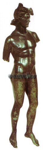
Coin
Evidence.
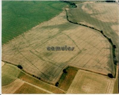
So, from archaeological
evidence, Gosbecks' history can certainly be
traced to the middle of the first century BC.
Coins were introduced to Britain by the
Belgic people and give archaeologists a
powerful tool for dating finds. 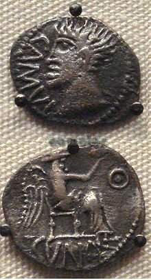 Whilst
the Belgic coinage that arrived in Britain
gradually spread in use throughout the land,
ascribing a mint or a date to it is not an
easy matter. The first identifiable inscribed
coinage to emerge in this area is that of
Addedomaros,
dating to around 35 BC. He issued gold
staters (a large coin), as well as a range of
silver and bronze coinage. It is believed
that he was the leader of the
Trinovantes,
whilst his contemporary was
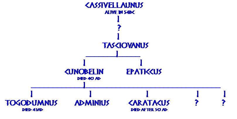
Tasciovanus
of the neighbouring Catevellauni
tribe, whose coins were being minted in
Verulamium
(modern day St Albans). For a time,
Tasciovanus
was minting coins from Camulodunum,
with the tell-tale letters CAMU, suggesting
an alliance or a conquest of some sort. He
died around the year 7 AD. In due course,
Addedomarus
was succeeded by Dubnovellaunus
and then Tasciovanus' son Cunobelin.
Whilst
the Belgic coinage that arrived in Britain
gradually spread in use throughout the land,
ascribing a mint or a date to it is not an
easy matter. The first identifiable inscribed
coinage to emerge in this area is that of
Addedomaros,
dating to around 35 BC. He issued gold
staters (a large coin), as well as a range of
silver and bronze coinage. It is believed
that he was the leader of the
Trinovantes,
whilst his contemporary was
Tasciovanus
of the neighbouring Catevellauni
tribe, whose coins were being minted in
Verulamium
(modern day St Albans). For a time,
Tasciovanus
was minting coins from Camulodunum,
with the tell-tale letters CAMU, suggesting
an alliance or a conquest of some sort. He
died around the year 7 AD. In due course,
Addedomarus
was succeeded by Dubnovellaunus
and then Tasciovanus' son Cunobelin.
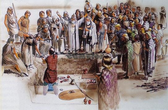
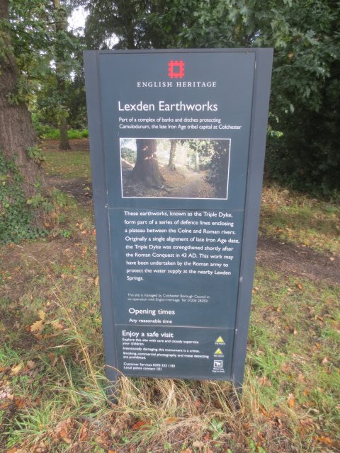
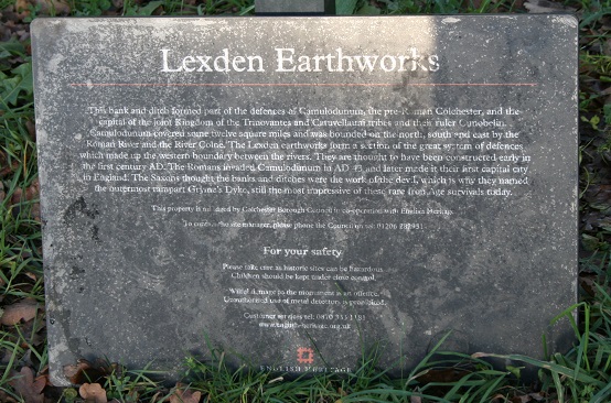
It has been suggested
that the Lexden Tumulus (as it is known, in
Fitzwalter Road) was the burial place of
Addedomarus,
dated to around the year 1 AD. The grave
contents were extensive and clearly belonged
to a man of great importance.
 Cunobelin
united the territories of the
Trinovantes
and the Catuvellauni
to form the most powerful kingdom in Celtic
Britain for the three decades before the
Roman conquest in 43 AD. The Roman
Seutonius,
in his 'Lives of the Caesars', described
Cunobelin
as 'Britannorum
rex' - the king
of the Britons.
Cunobelin
united the territories of the
Trinovantes
and the Catuvellauni
to form the most powerful kingdom in Celtic
Britain for the three decades before the
Roman conquest in 43 AD. The Roman
Seutonius,
in his 'Lives of the Caesars', described
Cunobelin
as 'Britannorum
rex' - the king
of the Britons.
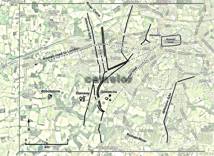
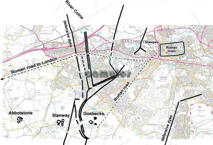
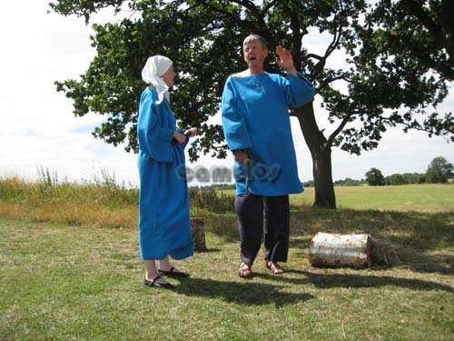
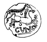
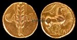 The
several illustrations here show some of the
images depicted on coins of the period.
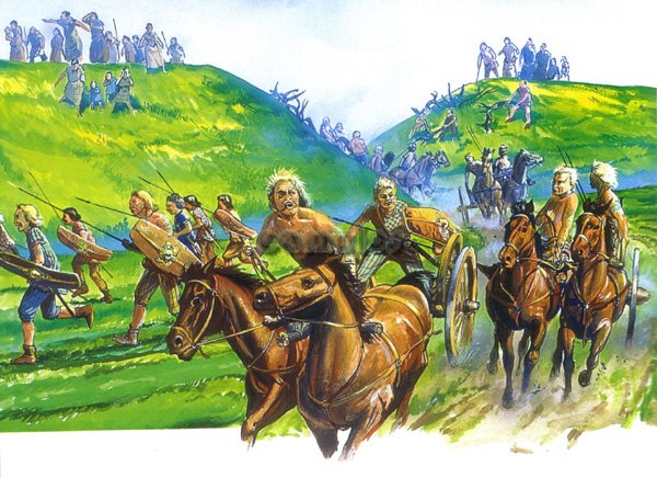
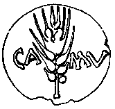
Cunobelin's first coins were minted in
Camulodunum,
with CAMU on one side and a two horse chariot
or biga (as encountered by Caesar many years
before), on the obverse. His later coins
adopted an ear of wheat or barley, also CUNO,
short for Cunobelin,
as well as a single horse. Archaeologists
have not only found many examples of
Cunobelin's coins but also the coin moulds,
found in the industrial area of
Camulodunum
at Sheepen.
The
several illustrations here show some of the
images depicted on coins of the period.
Cunobelin's first coins were minted in
Camulodunum,
with CAMU on one side and a two horse chariot
or biga (as encountered by Caesar many years
before), on the obverse. His later coins
adopted an ear of wheat or barley, also CUNO,
short for Cunobelin,
as well as a single horse. Archaeologists
have not only found many examples of
Cunobelin's coins but also the coin moulds,
found in the industrial area of
Camulodunum
at Sheepen.
Tasciovanus
died around the year 7 AD and was succeeded
by his son Cunobelin.
It is believed that Cunobelin
was responsible for the merging of the
Catuvellaunian kingdom with that of the
Trinovantes.
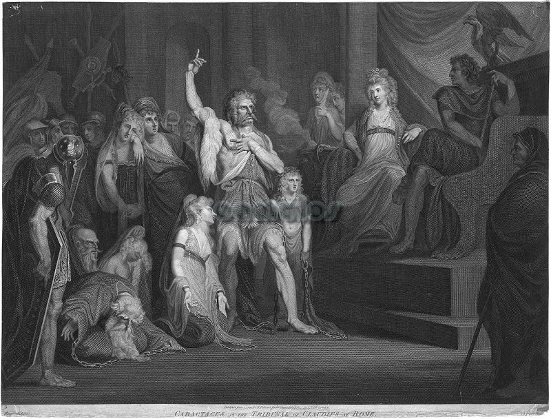
Cunobelin
died around 41 AD. His son
Caratacus
succeeded him but appears to have fled to
Wales with another of his sons,
Togodumnus,
following the Claudian invasion. The
opportunity for a Roman invasion was provided
in 42 AD by the flight to Rome of
Verica,
King of the Atrebates
of modern day Sussex. The Atrebates
had been steadily encroached upon by the
increasingly powerful Cunobelin
and his sons. In 42 AD they were overrun by
Caratacus
and Togodumnus.
Verica
appealed to Claudius
for assistance, giving the Romans a
convenient reason for a full scale Roman
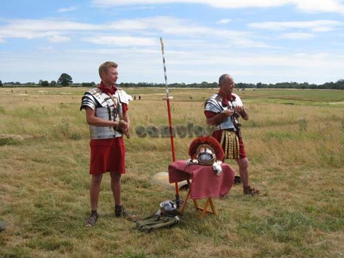
invasion. After landing in Kent, the Roman
army made their way to the most important
settlement at Camulodunum,
having dealt with attacks by
Caratacus
and Togodumnus
on the way. They waited for
Claudius
to join them from Italy, before making the
final leg of their journey, allegedly with
elephants, leading a victorious army into
Camulodunum.
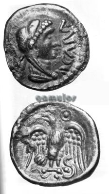
Note the coin on the
right of the page above. What is the
significance of the images? Is this the face
of Cunobelin, with spiky hair and strong
features. On the reverse side, a winged
seated goddess - an angel perhaps? The angel
is very similar to that shown on the top of
Longinus Sdapeze's tombstone, now in the
castle museum.

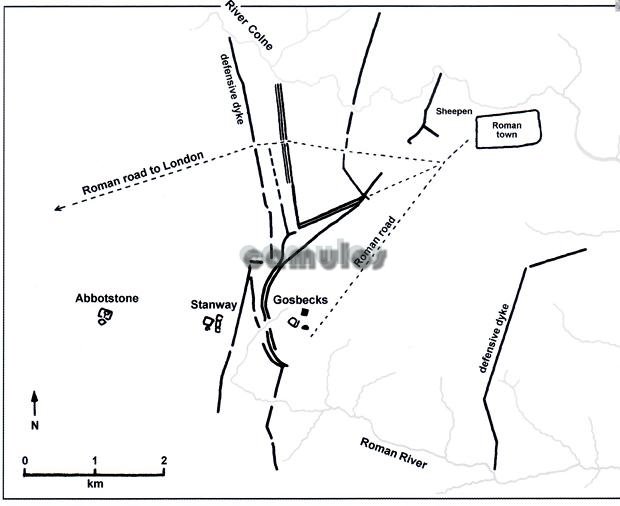
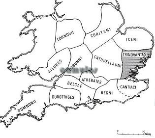 Evidence
of human activity in Britain, as far back
as 150,000 years, has been discovered.
But, apart from substantial archaeological
finds from pre-history and the Bronze Age,
we can only properly start to tell
Gosbecks' story from the Iron Age period
(500 BC to 43 AD). Let us start with the
map shown here. This shows how the
southern part of Iron Age Britain was
divided up by powerful tribal kingdoms of
that time. The area that we now know as
Essex and much of Suffolk was controlled
by the British tribe known as the
Trinovantes.
We first learn of them from the historical
record of Julius
Caesar, from
his two exploratory British campaigns in
55 and 54 BC. He told us that his
principal opponents during the 54
BC campaign were the
Catuvellauni
and the Trinovantes.
Just before Caesar's arrival, the
Catuvellaunis had defeated and killed the
Trinovantian king, whose young son,
Mandubracius
had then sought the protection of Caesar.
His tribe had therefore become Caesar's
allies.
Evidence
of human activity in Britain, as far back
as 150,000 years, has been discovered.
But, apart from substantial archaeological
finds from pre-history and the Bronze Age,
we can only properly start to tell
Gosbecks' story from the Iron Age period
(500 BC to 43 AD). Let us start with the
map shown here. This shows how the
southern part of Iron Age Britain was
divided up by powerful tribal kingdoms of
that time. The area that we now know as
Essex and much of Suffolk was controlled
by the British tribe known as the
Trinovantes.
We first learn of them from the historical
record of Julius
Caesar, from
his two exploratory British campaigns in
55 and 54 BC. He told us that his
principal opponents during the 54
BC campaign were the
Catuvellauni
and the Trinovantes.
Just before Caesar's arrival, the
Catuvellaunis had defeated and killed the
Trinovantian king, whose young son,
Mandubracius
had then sought the protection of Caesar.
His tribe had therefore become Caesar's
allies.