![]()
|
|
|
![]()
|
|
|

1a
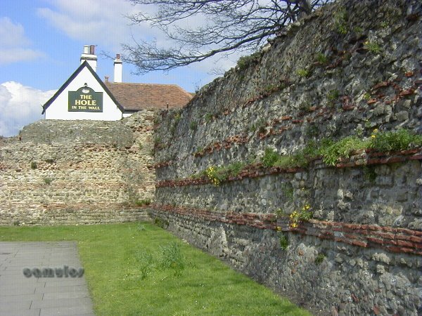
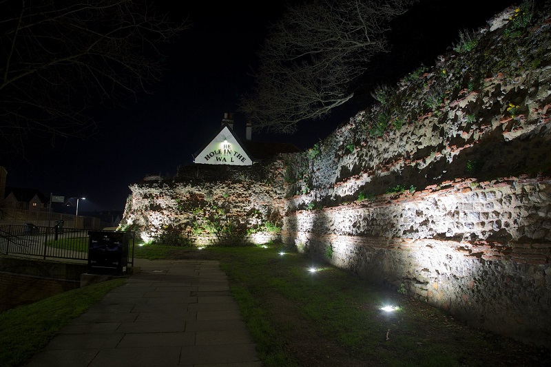
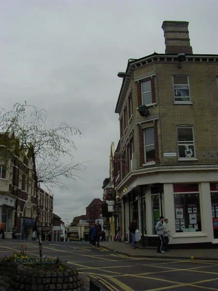
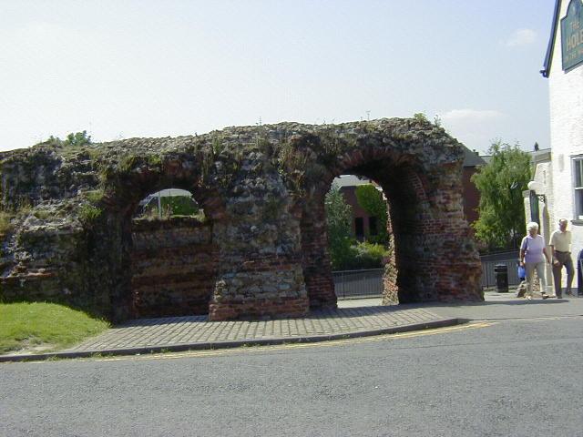
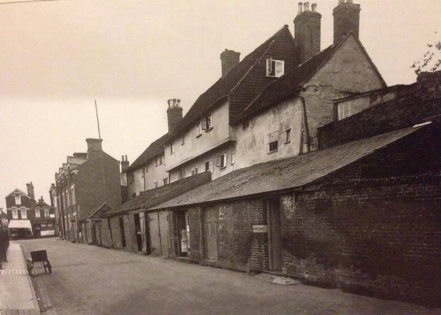
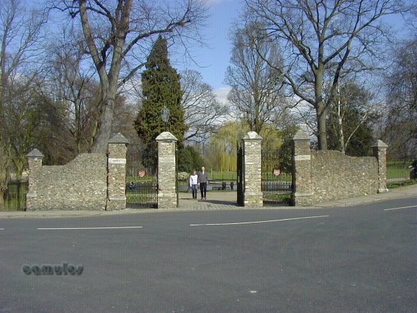
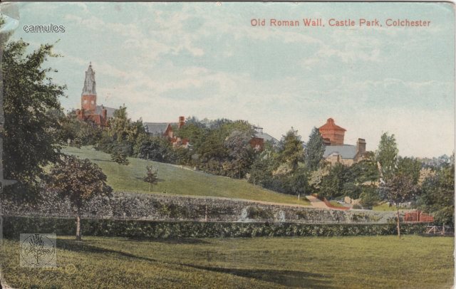
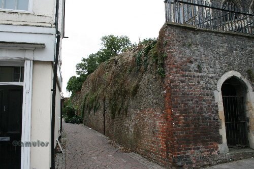
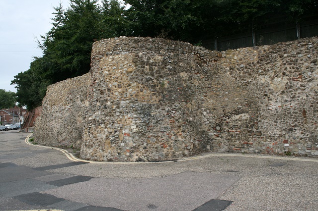
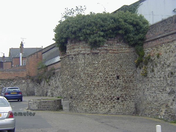
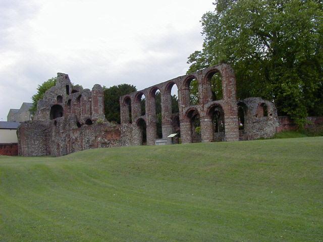
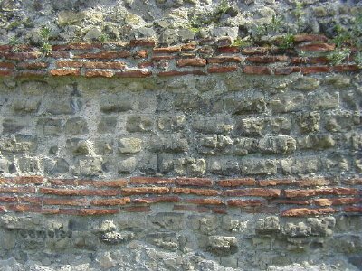
BALKERNE GATE FROM OUTSIDE THE WALL, LOOKING EAST
This is a picture of the outward facing Balkerne Gate as we see it today (we will talk about the shields that you can see on the wall below, when we return to this point at the end of our tour). As you can see there is only a fraction of the gate left, although it still remains the earliest and the most complete Roman gateway in Britain. Archaeologists have extensively explored the foundations and features and have found some very interesting rainwater or sewerage drains in this area.
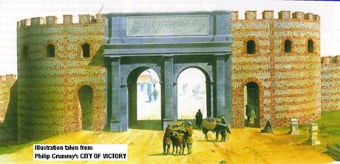
The following picture shows what this triumphal arch might once have looked like, after it had been added-to by the building of what we know as the Balkerne Gate.
1b
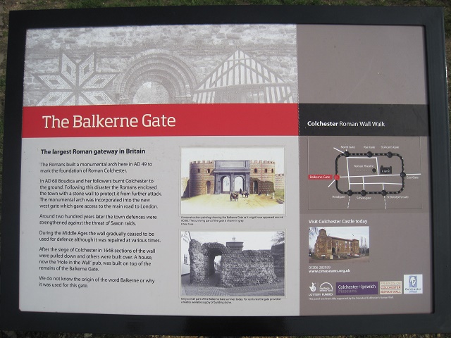
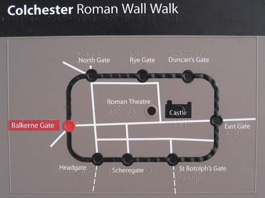
Here follows the first of a series of 13 information boards that were installed around the wall, to assist and inform anybody that wanted to know more about this remarkable monument. We will see more of these signs as we go round the walls.
1c
1d
The gate faced west . Why? For a start it would have looked towards the place we now know as Sheepen, an area of Camulodunom known to have been where the indigenous British people lived and worked. Much evidence of industry has been found there and the siting of the arch would have been a powerful image for the conquered people to see on their line of sight. Another important part of the British settlement was based at modern day Gosbecks, two miles away. It is also believed that the arch position was here because this was the main entrance point to the colonia, facing in the general direction of London (Londinium) and St. Albans (Verulamium).
Some time after the destruction of the colonia by Queen Boadicea and her army in AD 60/61, the construction of the wall, that would encircle and protect the populace, was begun.
On the subject of the way the gate faced, it is interesting to note that the road layout of only two British Roman towns (that of Colchester and Silchester) are aligned on an exact true north/south alignment, our North Gate and Head Gate being within a half degree. This shows the precision of the first town planners, who would have used the sun's movement to plot a cast shadow arc and then bisect it for a true north position.
From ancient documents, we know that the Roman writer Tacitus chastised the Roman authorities for not providing the colonia with a wall. Whether or not a wall would have been sufficient defence against Boadicea, remains unknown, as the might of the Roman army in Britain was away in the west at the time, leaving the colonia lightly defended. Boadicea would have known this and would have made her plans accordingly.
1e
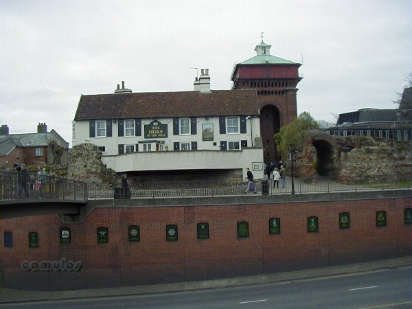
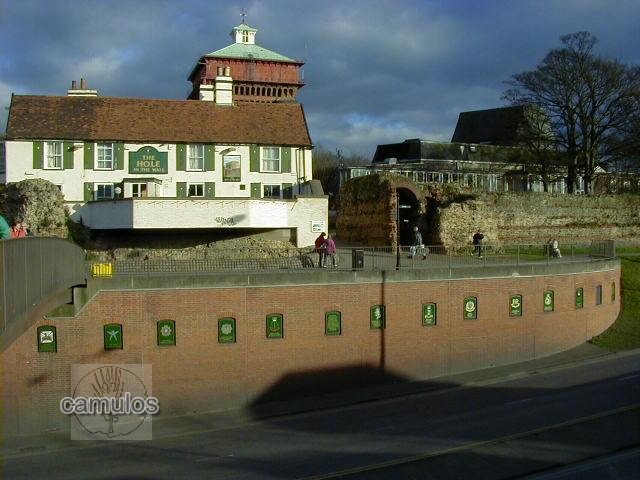
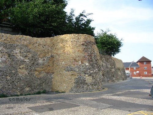
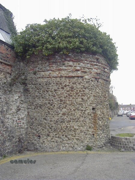
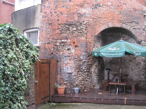
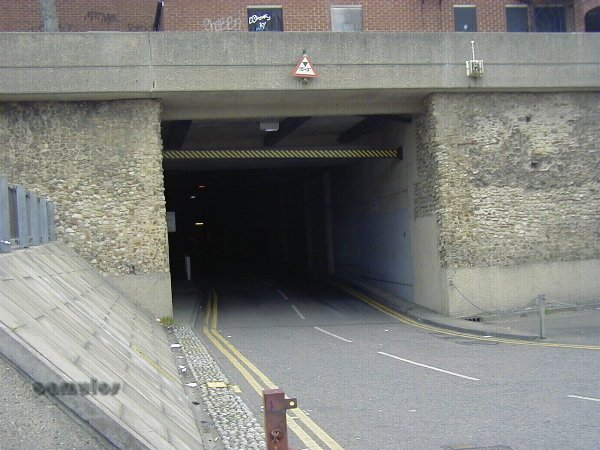
BALKERNE GATE LOOKING WEST WITH JUMBO BEHIND US
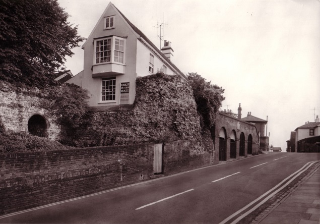
We have now walked through the gate, into the colonia (as was), imagining the greeting that we might have had from sentries all those years ago, eyeing us suspiciously and enquiring as to the nature of our business. Turning back on ourselves with the Jumbo water tower behind us and looking west, we see the gate from the other side, the single footway arch alongside what is assumed to have been a guardroom. The Hole in the Wall pub is on the right, built directly onto the Balkerne Gate.
1f
1g
BALKERNE GATE FROM INSIDE THE WALL LOOKING WEST INTO THE GUARDROOM
It was only around a hundred years ago that this structure was properly uncovered, which is probably how it managed to survive in the condition that it has. The flooring is modern but everything else that you see is pure Roman.
1h
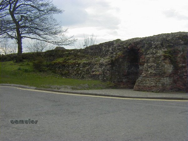
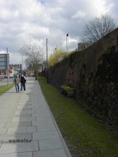
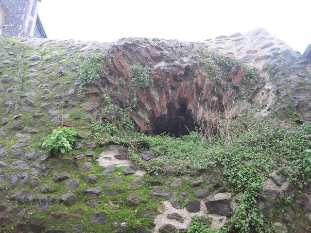
A VIEW TO THE LEFT SHOWING THE RAMPARTS
To the left also we can see the suggestion of the raised ground that was once the wall's ramparts. This gave the defenders (i.e. the Romans) a distinct height advantage over any attacker, especially when you remember that the entire town wall was at once surrounded by a defensive ditch to add to an attacker's difficulty. The present day road level of Balkerne Hill is much lower than the original Roman level, having been cut back in the 1960s, leaving the 'Hole in the Wall' standing out 'like a Tibetan Monastery'.
We now walk back through Balkerne Gate to outside the wall.
1i
1j
1k
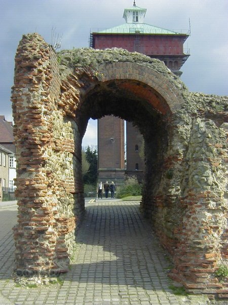
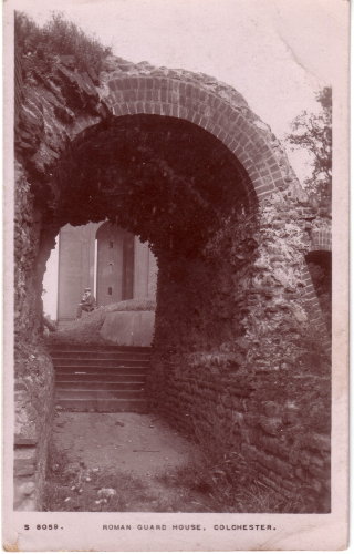
THE PEDESTRIAN ARCH LOOKING EAST, WITH JUMBO IN THE BACKGROUND
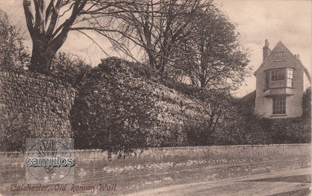
(and old postcard views from around 1910)
This is the opposite view to the one where we were looking into the guardroom. Again, the remains are well preserved, but with a little modern brick repair work in the top of the arch.
1l
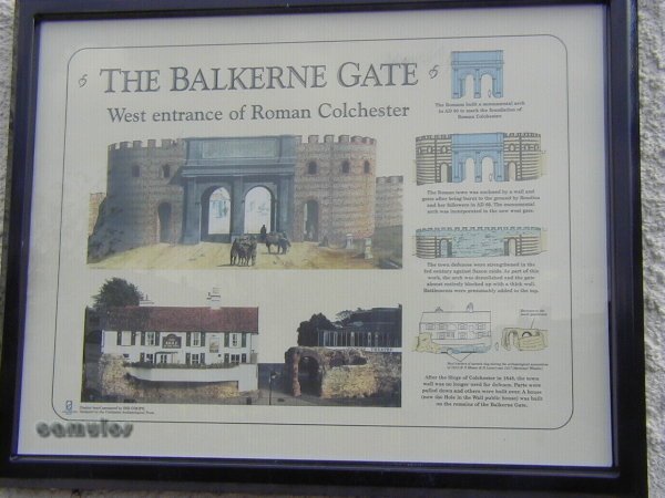
THE BALKERNE GATE DISPLAY BOARD (old one)
This display board is affixed to the gateway to explain the structure's history. On the right hand side of the board, the top view shows the triumphal arch, the next shows the added gateway, the third showing the gate sealed up. The final view is how we now see the remains of the gate, much of it destroyed and built onto by the building that is now known as the Hole in the Wall public house.
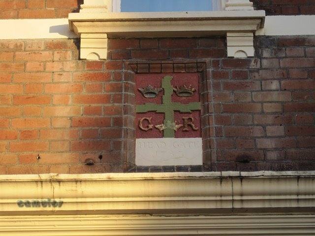
So where did the name Balkerne Gate come from? The original Roman name for the gate has been lost with time. It became known as the Balkerne Gate, a reference to it being baulked, stopped-up, bricked-up, sealed-up - in antiquity. It appears (from archaeological studies) that this gate fell into disuse at some point during the Roman period, perhaps because the Head Gate was a more convenient (and less of an incline) entrance point into the colonia. Indeed, it is because it was baulked that the gate has survived as much as it has and that Jumbo could be built on what would have originally been the High Street. All our other town gates have disappeared, allowing for greater traffic flow. Modern day vehicles are much larger than the horse and carts that people would have used two millennia ago.
At some time (experts cannot be sure about when it was blocked and when it was unblocked), the decision was taken to unblock the gate, which is why we are now able to walk through two of the four access ways; the other two being underneath and part of the foundations of the Hole in the Wall pub.
1m
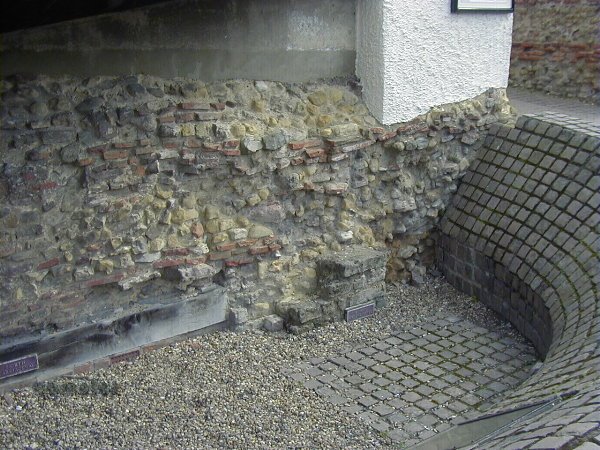
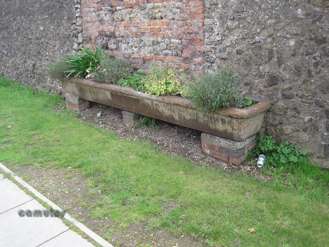
THE ARCHAEOLOGICAL EVIDENCE 1
When Balkerne Lane was lowered in the 1960s, the general area was subject to an extensive archaeological survey, which revealed an amazing amount of information about how this area developed during the Roman period. I shall not go into that in much detail other than to say that this picture shows the evidence of the main carriageway and the triumphal arch.
1n
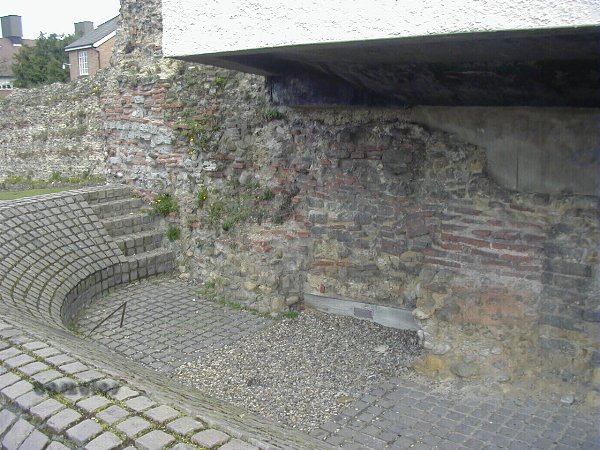
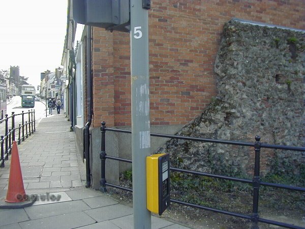
THE ARCHAEOLOGICAL EVIDENCE 2
Moving on towards point 2, we pass the left hand carriageway where we are able to get an impression of the huge size of the gate. We can see the soft tufa stone that the triumphal arch was constructed from, in contrast to the later wall materials.
1o
1p
1876 Ordnance Survey Map, before Jumbo, with the wall shown north south and with housing on both sides of the road.
1q
A photograph from the 1970s, before the road was lowered.
1r
An old postcard view from before Balkerne Hill was lowered in the 1970s.
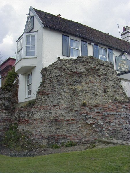
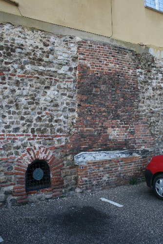
A little further on we look back to see where the Hole in the Wall got its name from (above). The pub was once known as the Kings Head but, in 1843, the railway came to Colchester and the landlord of this ancient tavern saw an opportunity for increased business. In a single act of archaeological vandalism, he bashed a hole through the Roman gate's structure to open up a view of the railway to the north. Thereafter, the local people awarded it the nickname of 'The Hole in the Wall', a name that was officially adopted in the 1960s.
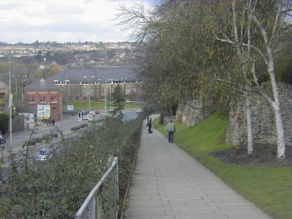
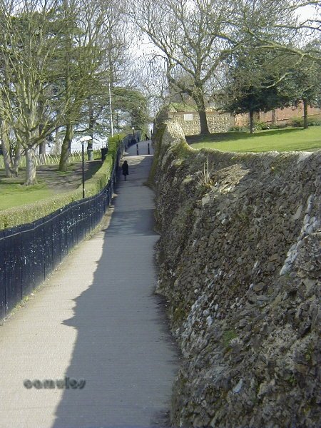
We started our tour at the most interesting and best preserved part of our famous walls. Regrettably it is mostly downhill from here - literally. We are going to trace the wall along its entire length, with many sections missing, some in poor repair, some completely hidden by buildings that have been built on top of them. We will have walked approximately 3000 metres by the time we get back here for a pint at the Hole in the Wall. I hope that you enjoy the rest of the tour.
Each year, the Colchester Town Watch take a perambulation of the entire wall perimeter, a tradition of old, whereby the people of the town could thank them for keeping the town safe from rogues and trouble makers. Cakes and ale were traditionally offered, although the odd dead cat or chamber pot content were, no doubt, sometimes involved. This tradition was revived in 2001, and the mayor, civic dignitaries and the great unwashed general public are invited to come along for the walk, where cakes and ale might be to found along the route.
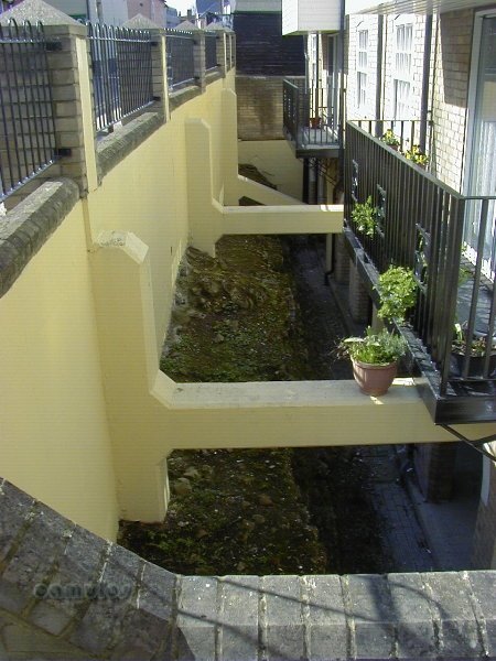
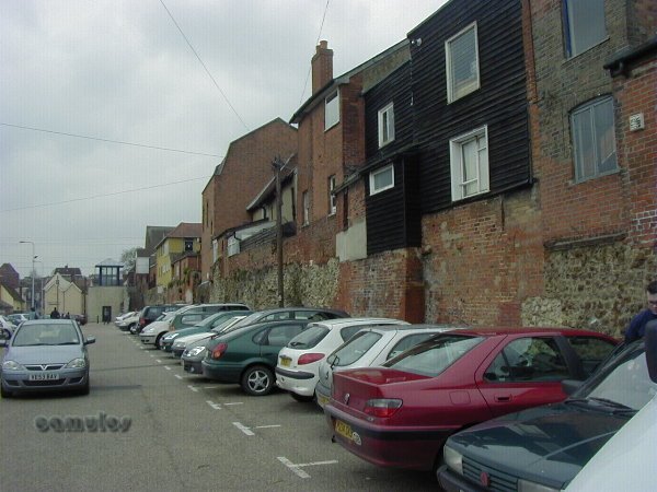
We now move on down the steep Balkerne Hill in a northerly direction. Understandably perhaps, we cannot get clear access to both sides of the wall as private properties, particular inside the walls, back right up to the wall itself. Our walls are not only classed as a scheduled ancient monument (SAM) but are also Grade 1 listed, with all the protection that is afforded to this remarkable structure. In some areas, the walls are completely obscured by buildings - but more of that later!
1p
BALKERNE HILL WITH THE WALL ON THE RIGHT AND THE RED BRICK PUMP STATION ON THE LEFT
To the left we see a brick built building of the Victorian age. Built by Peter Shuyler-Bruff, it once housed a steam driven pump, to pump fresh water up the hill to the Jumbo water tower which was built in the 1880s. I mention this because, here we have an inkling into what the Romans must have been thinking when they chose their site for the colonia. This part of Colchester, at the foot of the hill, is renowned for its springs - fresh water - so essential for healthy living. We have never positively discovered any Roman baths in Colchester (some bath type structures are known from the work done at the Sixth Form College in the 2000s) but we would expect that this would have been where they were, for the simple reason that it was here that there was fresh, pure water; an easy supply that could be heated and used to wash the dirt and grime away after a hard day at the forum.
1q
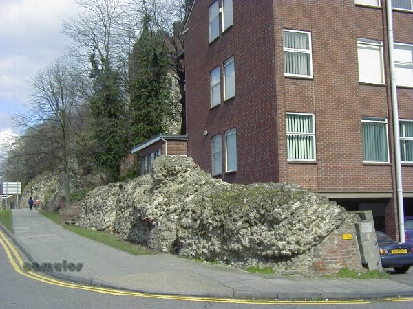
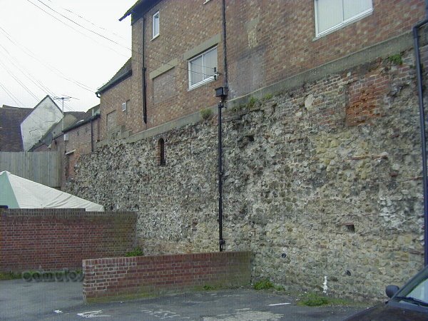
EVIDENCE OF A TOWER
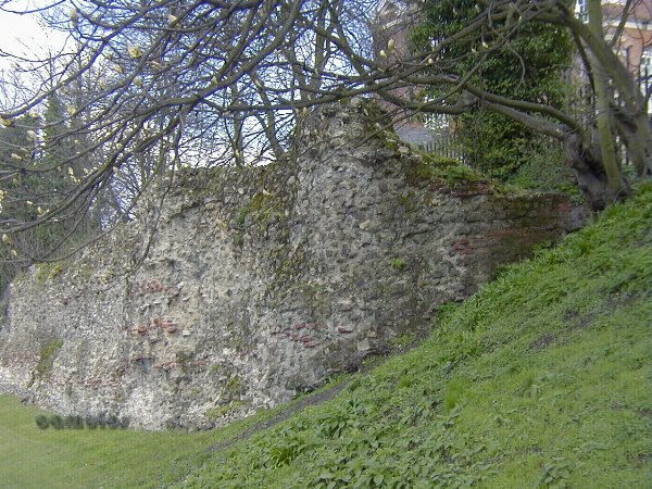
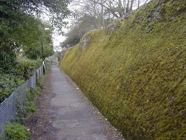
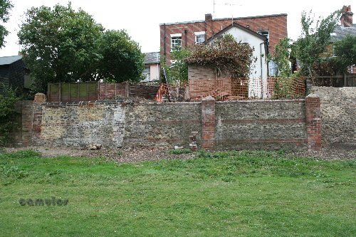
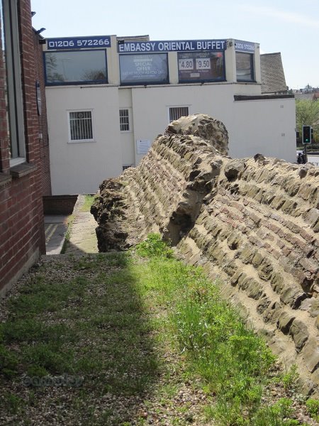
Half way down the hill quite a bit of the wall is missing (some of it perhaps due to cannon damage during the Civil War of 1648), although here on the right at the top of the wall section, can be seen evidence of one of the Roman period lookout towers that would have existed at various vantage points around the wall's perimeter. To the south, uphill, a complete section of the wall is missing. Philip Crummy believes that this is because the presence of a Roman drain (always close to a tower or gate) introduced a weakness which helped with a collapse of the wall from undermining, or subsidence of the outer earthworks.
1r
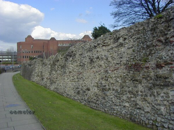
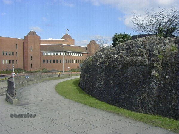
APPROACHING SHEEPEN CORNER
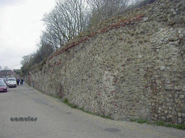
The walls here have been heavily repaired and rebuilt over the centuries, although, in places, you can still see evidence of the Roman tile and septaria courses. We are reaching the foot of the hill and arrive at the next point of our tour, with sections of the wall, in varying states of repair on our right.
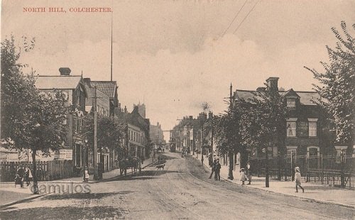
3a
NORTH GATE LOOKING SOUTH, UP NORTH HILL
3b
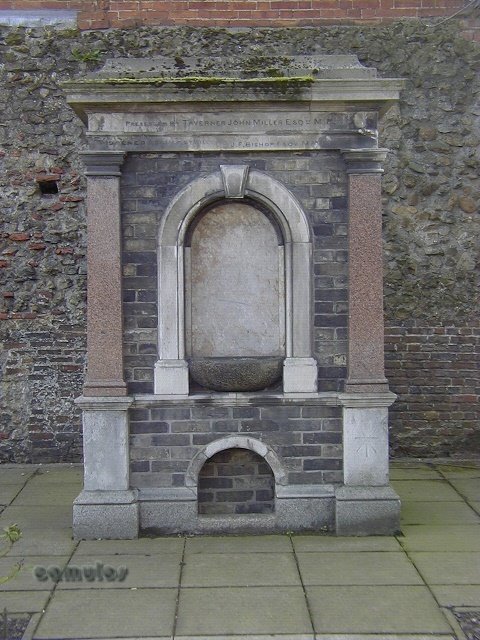
TAVERNER JOHN MILLER'S WATER FOUNTAIN
This fine looking structure was originally located at the 'new' market, across the road, where animals were brought to market for sale. The original market used to be the High Street, but the smell and the dust became just too much for the townsfolk and a new location was found here, alongside where North Gate used to stand.
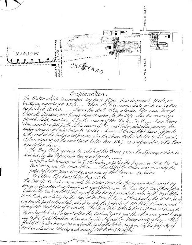
The following is an extract from a document dated from the 1830s, giving us a tantalising glimpse of how the North Gate once was. Quite narrow, as drawn. Perhaps this gate too had been balked in antiquity, like Balkern Gate to the west of the colonia. The document is part of a lease or debenture for what was once Cobbold's Brewery. The reason that the brewery was located there was because of the presence of natural springs, which provided the water needed for brewing. There were cisterns built here to collect the water, and various properties in this area also benefited from this 'liquid gold'.
3c
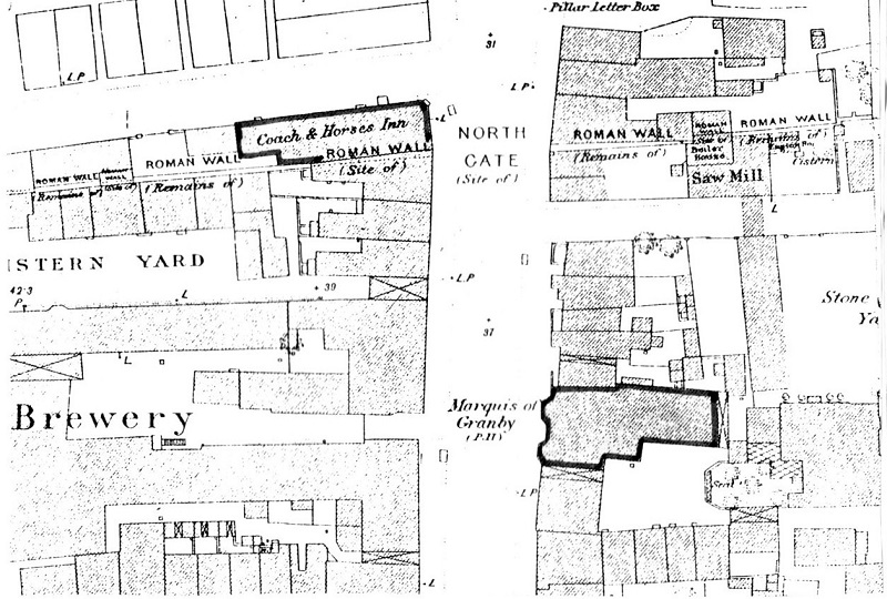
The following is a section of the 1876 Ordnance Survey map, showing how the old North Gate had been removed by then, Cobbolds Brewery was gone and a pub had been built on the north side of the wall.
3d
Here follows an old postcard image, looking south through where North Gate would have once stood and another showing a different view of Balkerne Lane.
3e
3f
As I mentioned earlier, all evidence of the Roman North Gate has disappeared as a road widening exercise. The following picture, is all that is left of what once have been an impressive structure, perhaps equally as impressive as Balkerne Gate. One day maybe, an archaeological survey might tell us more about the size, layout and position. North Gate was removed in antiquity and no record has been kept of its appearance, although our archaeologists say that the east foundations are intact and recorded.
3g
THE EAST SIDE OF NORTH GATE
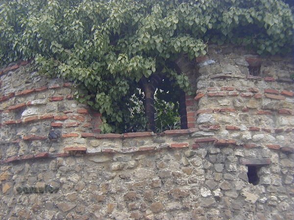
Just a small witness to the wall, squashed between two buildings, probably of medieval period. The Roman wall was originally approximately 2.4 metres thick, so a considerable amount of the wall is missing here. Behind this section, a short way along St Peter's Street, we find further evidence of what is left of the wall.
3h
3i
Very much in poor condition, with the weight of recent (cavity wall brickwork tells us this) buildings bearing down on it.
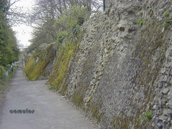
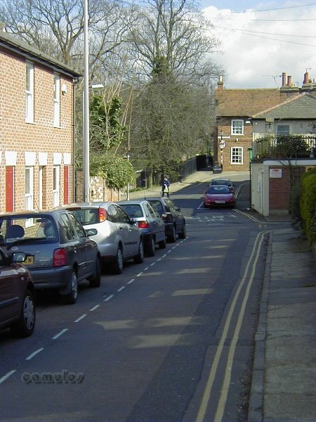
We now proceed along the route of the north section of the wall, along St Peter's Street, with a section of the wall on view on the right, before it disappears from view within the buildings that exist there. The wall has either been demolished or incorporated into the structures of the houses and other buildings along the route. The river Colne is within 100 metres to the North and runs east, through various mill and weir sites, towards the Hythe and out to sea.
After a distance of approx. 100 metres we turn right and up to Northgate Street. Notice how the gradient changes from what would have been outside the wall, to the height inside the wall. When the archaeologists delved in the area that is now grassed, they found evidence of a Roman wall observation tower.
3j
A SECTION OF THE WALL IN NORTHGATE STREET
As we walk along Northgate Street, we have many timber framed buildings of the Dutch Quarter on the right. The Victorian period houses on the left have been built directly onto the Roman wall and it would be nice to know whether their cellars show the wall in any way. After a short distance we are able to look over to the left to see a section of the wall exposed where car parking has been provided. This gives an idea of the height of the Roman wall as it would once have been.
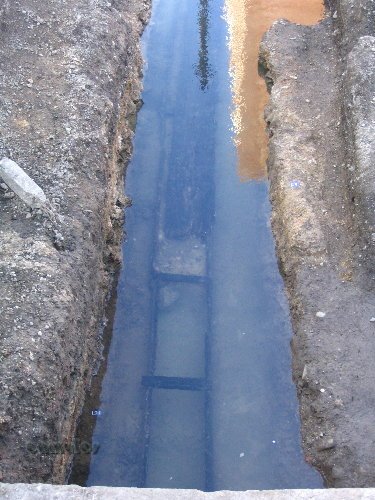
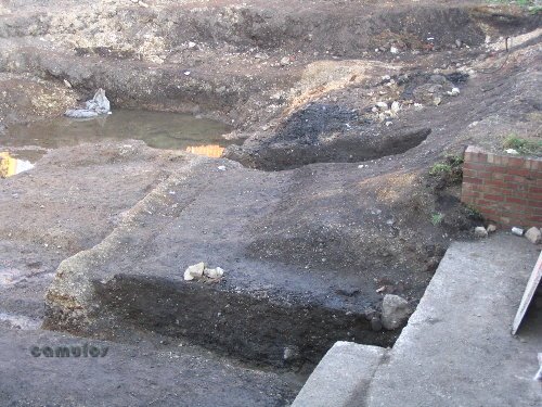
At this point, we are going to show you a photograph that we took on Saturday 16th February 2008 whilst standing on the pavement in Northgate Street, close to the above picture. By the time you come here and see this picture, this exposed Roman drain (c50AD) has been completely built over. The importance of this picture (below) is that it changed the thinking of archaeologists. It was a complete surprise to them, especially as the approximately 350mm x 350mm wooden plank drain construction c AD 50 had been preserved due to its waterlogged state. Furthermore, our archaeologists believed that, where there is a drain, there is a tower or a gate in the wall. Indeed, their excavations revealed a metalled road surface, as shown on the second picture, meaning that this was a previously unknown gateway into the town. The jury is out as to how they should interprete this find, because it could mean that, if such a gate exists here, is there a corresponding gate on the south face of the town wall, and other similar gates at the positions of the medieval bastions that you will later come to during the course of your virtual walk around the wall?
Following on from this, the archaeologists were able to confirm the finding of three drains, that dendrochronology tests on the wood gave a date of AD62 (therefore predating the Town Wall itself), that the two other drains were of a similar construction and that a gravel 'road' surface was between them.
3k
The wooden drain discovered in February 2008, completely preserved by waterlogging, viewed looking north from Northgate Street.
3l
This view is looking to the right from the previous picture position and shows the metalled road surface and beyond that, a later Roman drain, which would have discharged excess water into the town ditch and away to the nearby river .
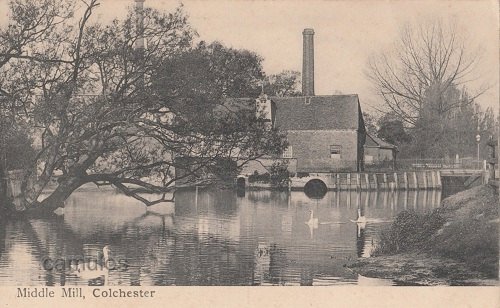
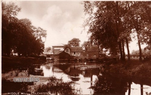
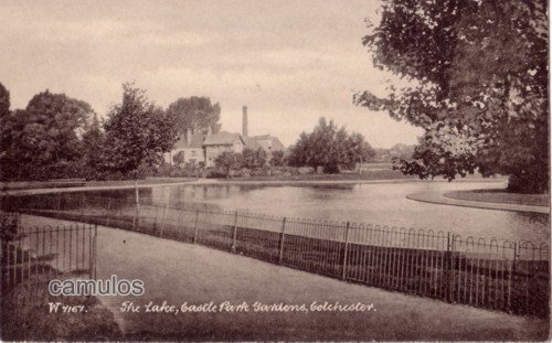
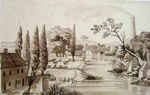
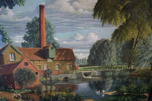
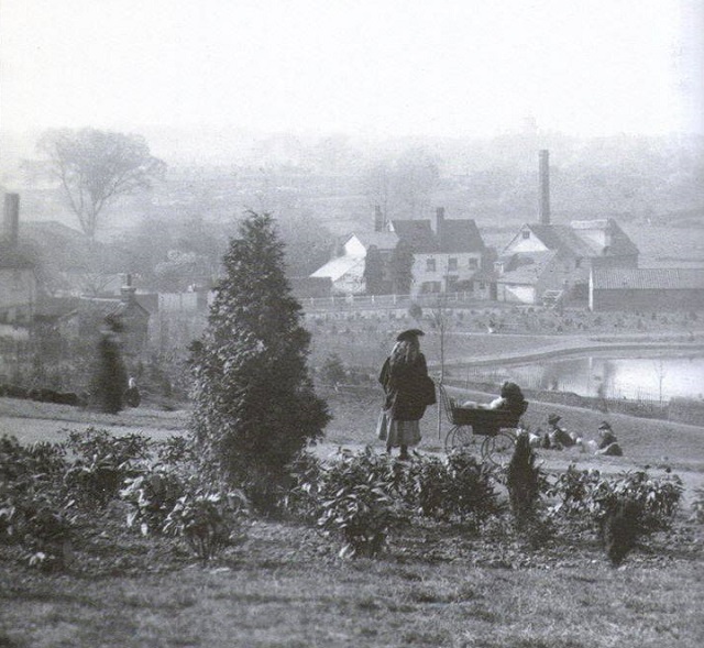
Moving on, we will soon arrive at the area known as Rye Gate, believed to be a medieval gate cut into the wall to give access to a medieval mill known as Middle Mill, demolished almost 50 years ago. The area has been landscaped considerably over the years and made into one of the principal entrances into the lower castle park.
3m
MIDDLE MILL
A few old picture postcards and other images.
3n
3o
3p
3q
3r
3s
3t
3u
3v
3w
If you take a short walk across the river here you will pass by the sluice gates, all that is left of Middle Mill, one of several water mills that date back to our medieval cloth industry period. The views that these pictures portray, sadly, are no more. NORTHGATE STREET APPROACHING.....
4 - RYE GATE 4a
RYE GATE
Not Roman at all, Rye Gate serves as an elegant entrance to the beautiful Castle Park. All evidence of the wall has disappeared in this area, it having been extensively modified in the Victorian era, and in subsequent years.
4b
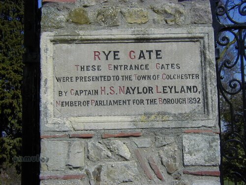
THE RYE GATE ENTRANCE
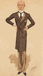
Capt. Herbert Scarisbrick Naylor Leyland was once an MP for Colchester. Born 1864, he joined the Life Guards at 18. Went round the world. A very rich man. This caricature of him appeared in the Vanity Fair publication in 1894. (1894.08.09)
Why the name Rye Gate, you may ask? The 18th century historian, the Reverend Philip Morant, stated,
'Rye-gate, as it is vulgarly called; or rather Rhee or Rea-Gate, that is the River-Gate, as leading to the River. It was anciently named the North, or King's Scherde. 'Twas taken down in the year 1659.'
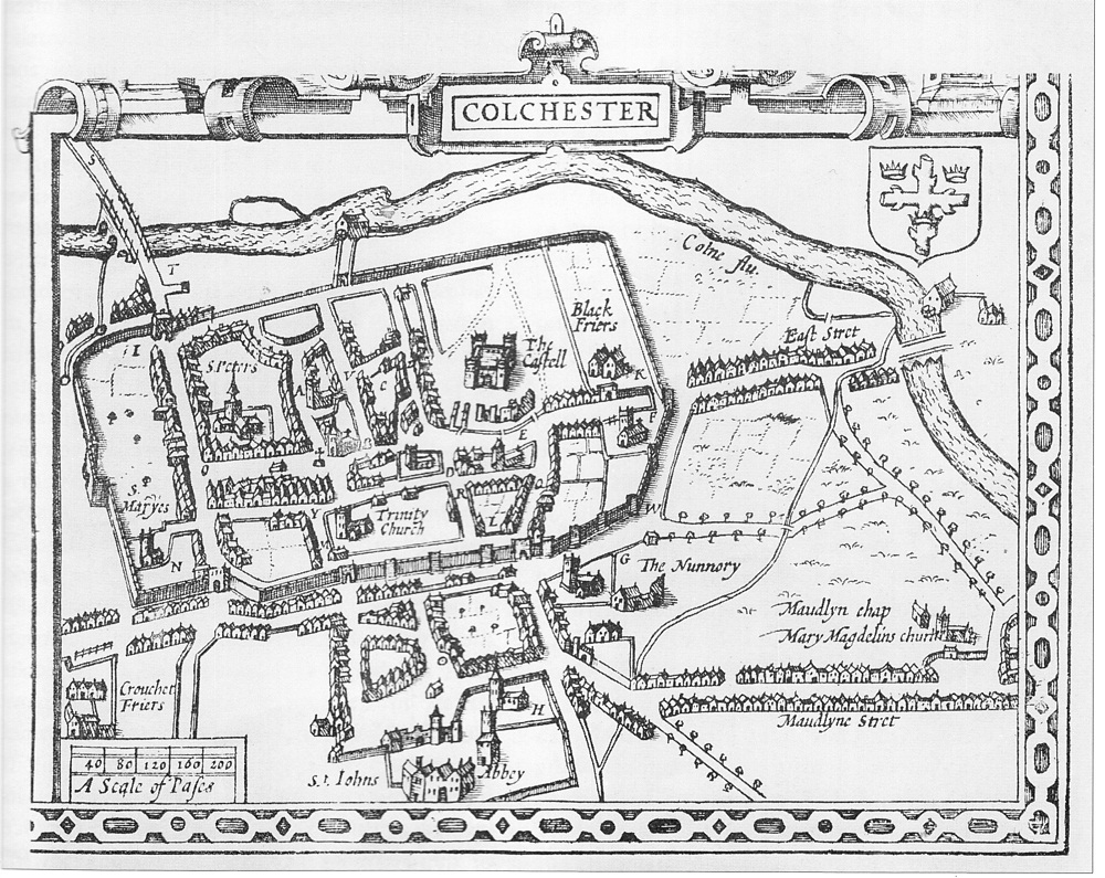
He referred to this gate as a 'postern', rather than a full 'gate', implying that it was a simple through way (see Speed's Map at the beginning of this page). Morant mentioned two other posterns as well, those at Sheregate and at St. Mary's. More of which later. Interestingly, he failed to make any mention of Balkerne Gate whatsoever, presumably because it was 'baulked' and not known as a gateway.
Please click here to read Morant's words on the subject of our walls, as well as further expert provided information.
Remember, we are still 'inside the walls' at this point.
4c
THROUGH LOWER CASTLE PARK
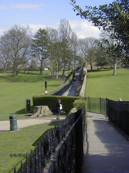
As we walk along this section, the reconstructed section of the wall is on our left, just over the railings, although we are about to follow the path that crosses over and will take us once more to 'outside the walls'. The castle is on our right. This section of the wall passes through our beautiful Castle Park. The wall has been substantially reconstructed. During the Siege of Colchester in 1648, contemporary accounts tell us that this was an area where the wall was missing and had to be fortified with a makeshift barricade to keep the parliamentary forces at bay. This is backed up by Speed's map at the beginning of this page. We don't know who demolished the wall and when or why, although it is quite possible that, being on sloping ground that was liable to flooding, the wall may simply have fallen over and become irrepairable.
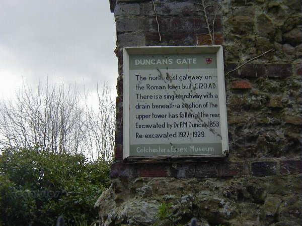
As we continue along the wall in an easterly direction, we come to what is known as a postern. This is a small gate through the wall (not a major thoroughfare), dating from the Roman period. It was re-discovered by a Victorian archaeologist by the name of Duncan and the gate took his name thereafter. Not as complete as the Balkerne Gate, Duncan's Gate is an excellent example of a postern. It is closed off to the public and we (the general public - or plebiae) can only see it now through metal railings.
6a
THE DUNCAN's GATE PLAQUE
6b
DUNCAN's GATE
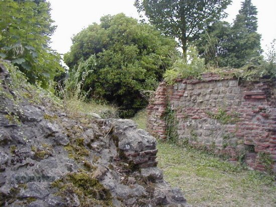
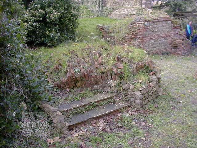
What is particularly remarkable is that the complete archway of the gate has simply collapsed at some point in time and lays where it fell, as can be seen in the next picture (taken from inside the railings). There are gratings (see below) in the grass on Hollytrees Meadow, to the south of this point, put there after an archaeological survey, showing an amazing Roman drain or water feature which passes under Duncan's Gate and away towards the river. Archaeologists are not sure what the significance of these drains are, possibly connected with a mithraem, and most probably connecting to the Roman temple in some way. As the drains are man sized, it is conjectured that then could have offered an escape route from the temple to the river, in times of attack.
6c
This whole area of our wall is crying out for development as a highly interesting tourist feature, which could include an attempt at a reconstruction of the gateway.
6d
THE FALLEN ARCHWAY OF DUNCAN's GATE
Whilst the picture is not easy to interpret (not helped by the addition of archaeology-destroying stone steps by some unthinking person), this is the fallen archway of Duncan's Gate, the Roman tiles that formed the arch clearly visible. Subsequent archaeological studies discovered that the gate had been set on fire at some point in history, presumably by an attacking force. We do know that the Danes attacked Colchester during the 10th century, with a record of Edward the Elder chasing them back 'over the walls'. We must assume that the walls were then in a fairly good state of repair as a walled town was a safe place to live. There are some who would argue (with good reason) that Colchester was King Arthur's 'Camelot'.
6e
ANOTHER VIEW FROM INSIDE
This further view of the gate shows one of the supporting walls, of similar construction technique to that at Balkerne Gate, where we started our tour.
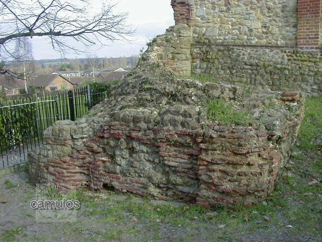
We should point out the obvious fact that the walls of the colonia were a major work of civil engineering and would have cost a great deal of money. They must have taken many years to complete. Due to a lack of natural building stone in the Colchester area, the walls had to be constructed from whatever was available. There must have been a considerable industry around the manufacture of the brick earth tiles and the collection of the septaria (fossilised clay) that was to be found in part close-by (there is evidence of septaria deposits having existed, between Duncan's Gate and the river, although by quarrying it to build the colonia, has removed details of how much there was). It is also to be found in the Harwich area. There was a ready made work force, in the form of the army, who had plenty of time on their hands, whilst they were also maintaining the security of the colonia. The cost of their wages alone must have been phenomenal, so putting them to some good use, keeping them occupied and out of mischief was a good idea.
Before we move on from this place, we should also point out that this postern gate seems to have given a means of access to a cemetery, just outside the walls. This cemetery is much smaller than the huge cemeteries to the south of the colonia and some interpretation of the types of burial, period, rites, would be of interest. Was it associated with a particular sect or class of people?
6f
LOOKING EAST FROM DUNCAN's GATE
This section of the wall has been substantially rebuilt with nothing of the Roman construction visible. What we are seeing here is the rubble infill of the original Roman wall.
6g
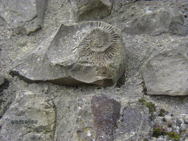
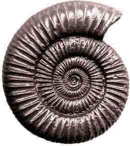
FOSSIL IMPRINTS IN THE SEPTARIA
A fossil expert could no doubt tell us the age and Latin name of this Jurassic (142 to 205 million years old) ammonite; long extinct marine animals that were so named because their coiled and chambered shells resembled the horns of the Egyptian ram god Ammon. Is this some sort of record for Colchester, we wonder?
Sections of our Roman wall exhibit what appear to be Jurassic fossils in the septaria, from as far back as 205 million years. These creature were cephalopods that once swam in the warm Jurassic Sea, some 34 degrees north of the Equator. Movement of the Earth's land masses over millions of years led to the formation of the continents as we know them today, which included good old Britain, leading eventually to the formation of the septaria that was to go to be used by the Romans for our wall. However, septaria belongs to the Eocene period of only 50 million or so years ago. The experts (GeoEssex) tell us that:
'Septarian nodules from the Jurassic do occur in the boulder clay of Essex, having been brought south from the north of Cambridgeshire during the Ice Age. These can contain traces of ammonites, and one or two might be found in Colchester’s Roman wall. However, the vast majority of the septarian nodules, or ‘septaria’, in the wall were harvested from the local London Clay and this dates from the later Eocene period and so do not contain ammonites. But some may contain the odd piece of Nautilus which survived the extinction at the end of the Cretaceous period. ' So, are our fossil ammonites from the Jurassic - or are they the Nautilus from the Eocene? Only the experts can say, based on our fossil evidence. What do you think? Whatever the case, our Roman wall's age pales into insignificance by comparison with that of the Jurassic era.
6h
6i
6j
6k
A modern-day ammonite Nautilus, distantly related to Jurassic ammonites.
6l
ANOTHER FOSSIL IMPRINT!
There are several other fossil imprints in this section of the wall. None are in evidence at any other part for some unknown reason.
6m
6n
ROMAN ROAD POSTERN
Cut through in the Victorian period, before the walls were scheduled and therefore protected against this sort or archaeological vandalism.
6o
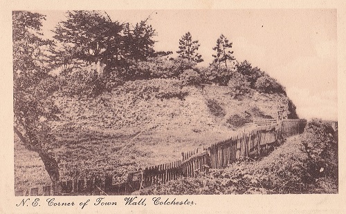
LICHEN COVERED WALL TOWARDS THE NORTH EAST CORNER
Allegedly, Colchester's north facing Roman wall has a unique type of lichen that is the subject of great interest to botanists. It has been suggested that it dates back to the Roman period, as it only thrives on our Roman walls. What we are seeing here is a moss covered wall, thriving in the ideal north facing and therefore moist conditions.
6p
THE NORTH EAST CORNER
Behind the wall is a private burial ground dating from the early Victorian period. There are many defined building features and buttressing on this section of the wall, most of it probably from the medieval period. It is likely that there was a Roman look-out tower at this point.
Here follows an old postcard view of this section of the wall. A much neglected section of the wall.
6q
We have no way of knowing how long it took to built the entire wall as this would have depended on many factors. Did the Romans built it in complete sections, moving around as each section was completed? Or did they have building operations going on at every point of the perimeter at the same time, to maintain a security presence at all positions?
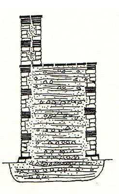
We will now quote directly from the words of Mr. Philip Crummy, Director of the Colchester Archaeological Trust and author of the best selling book, 'City of Victory'. 'The method of building the wall is well understood. During the excavations at Lion Walk and Culver Street, vivid evidence was found of the activities of its builders. At Lion Walk, the base of what had been a large stockpile of unused building stone lay a few metres from the inner face of the wall. And at Culver Street layers of small chips of septaria showed that the masons worked the septaria on the spot rather than at the quarry or in a yard, and patches of abandoned mortar laying on wooden boards indicated how this mortar was mixed on site.
6r
To build the wall, the Romans first dug a trench about 10 feet wide and about 4 feet deep. This was filled with layers of mortar and septaria which were simply poured or thrown in alternately until the top of the trench was reached. By this means the foundation was formed which, considering the height and weight of the structure it was to support, is surprisingly slight.
The wall itself is of ashlar construction. In other words the inner and outer faces were constructed independently of the core. The faces were raised, presumably a few courses at a time, and then the space between the two faces was filled with layers of septaria and mortar laid alternately just as in the foundation. The faces were made of neatly coursed septaria and tile, usually four courses of tile being followed by four or five courses of septaria. A small offset was formed at the base of the wall by making the lowest one or two courses slightly wider that the rest.
The purpose of the tile courses is not clear. The courses on the inner and outer faces match each other in terms of height above ground but do not connect up across the thickness of the wall. They are therefore not bonding courses intended to strengthen the wall. They may have been intended as a decorative feature. They may also have had a practical value during the construction work by providing a means of keeping the coursing even and on the same plane.' End of quote.
People often ask why the Roman wall builders failed to use flint for the wall. This is a readily available material in this area and can be seen in the walls of later Norman and medieval buildings, especially churches. In pre-historic times, flint was a valuable material, mined and traded (Grimes Graves is an excellent example of this) by people from the Stone Age period. It's main use was for making tools and weapons - and sparks for fire making. The Romans made the clear decision in Colchester, not to use flint and this is most probably due to the texture of the material, very hard and shiny, making it a poor material for their mortar to bond with. Or was it simply that the Romans didn't want any flint to spoil the look and fine lines of their incredible wall?
However, they did use flint for their wall in Verulamium (modern day St Albans), probably due to a lack of other building material and too far from the coast to make use of septaria. It may be noted that St Albans' wall did not survive very well!
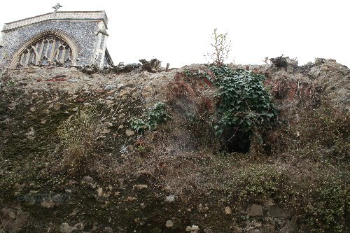
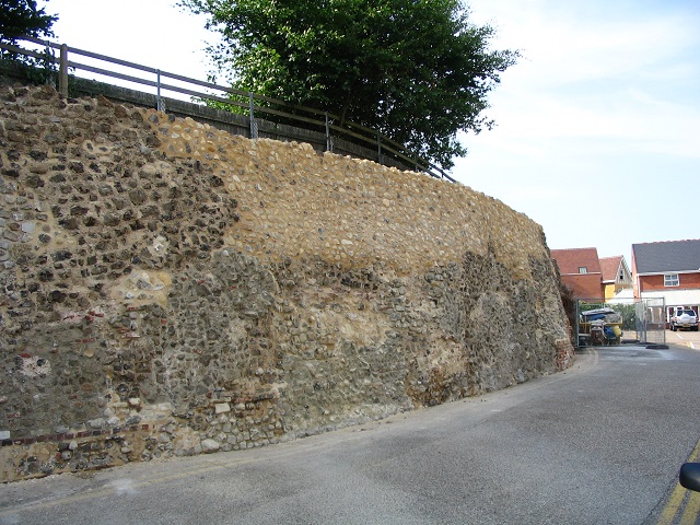
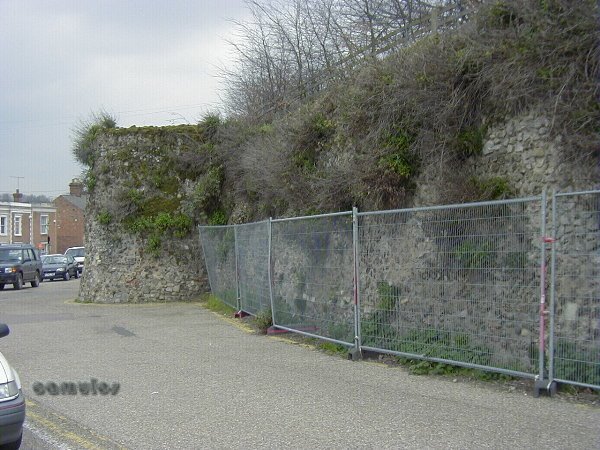
7 - THE EAST WALL Whilst the Castle Park is the jewel in our crown - our pride and joy - sadly, this section of our wall was a cause for great concern. It is still not very pretty, even after extensive restoration and stabilising work in 2009. It is out of sight and therefore out of mind and had been allowed to decay over a long period of time. Huge sections of this scheduled ancient monument (SAM) had been falling off, leaving the rubble infill to spill onto the ground. The owners of the Victorian-built houses along Roman Road, whose gardens abut the wall, seem to have made a valiant effort over the years to shore up and repair their section of wall, with a resultant mixed result and style being achieved. Many concerned townsfolk had highlighted this situation with our borough council and with English Heritage; official bodies who have responsibility for caring and protecting our heritage.
Thankfully, their concerns were rewarded with activity to make some sort of an attempt at repair and stabilisation. Please see below the various pictures taken in July 2009, showing the work that has been done and was in the process of being done by specialist contractors, Bakers of Danbury, under the instruction of the borough. The original Roman outer wall has completely disappeared above ground level, with only stabilising work possible to the rubble core. Any Roman brick on show would be from the inner wall, showing just how thin the wall had been allowed to decay over several centuries. However, archaeologists have delved below ground level and confirm that the wall in its original form still exists in good order. It is lovely to see that our walls are protected and conserved for future generations to enjoy, even if so much has been lost forever.
7a 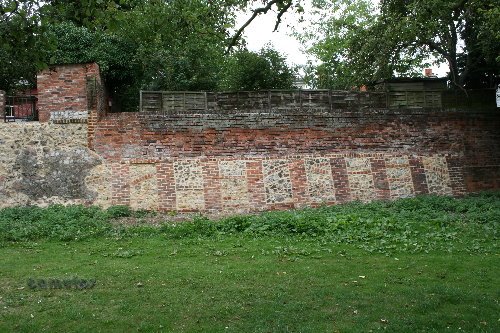

7b
7c
The Pirian declaration of the Walled Town Friendship Circle says:
Walled Towns are unique inheritances from times long past and should be treasured, maintained and safeguarded from neglect, damage and destruction and passed on into perpetuity as irreplaceable 'Timestones of History'.
Continuing our tour we walk for a time across a grassed area, and then on to Land Lane where we will soon arrive at East Hill and the site of the East Gate into the colonia.
8a
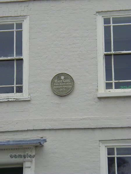
PLAQUE ON EAST HILL
In case you cannot read this, the plaque states that:
EAST GATE
FELL DOWN 1651
REMAINS REMOVED
1675
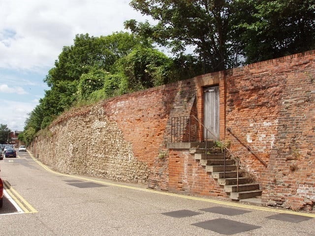
Across the road, there is no obvious evidence of the Roman wall, although its remains are there, the higher ground that is 'inside the wall' being occupied by the magnificent St. James the Great church. Indeed, the height of the church is a clue to how this section of the wall once was. East Hill has been cut away to make the gradient easier, where once would have been a much steeper section, around 3 metres higher, to suit the gate that once stood here. We can only assume that this lowering of the road occurred around 1675 when the Roman gateway was removed. The red brick courses that can be seen at low level is the 17th century underpinning on which the Roman wall foundations sit.
The same thing, lowering the road height to lessen the gradient, was also done on Balkerne Hill in the 1970s.
8b
Whilst the brick wall shown above is below the level of the foundations of the original Roman wall, there is a Roman drain, just above what would have been the Roman ground level and, as usual, sited close to a Roman gate. A better view of the unkempt drain is shown below, some 3 metres above the current road level. It is not an obvious feature, due to the destructive encroachment of undergrowth. However, the barrel vaulting of the drain arch can be picked out close to the top of the wall, suggesting that the Roman wall was once some 4 metres higher than it now is. This feature gets an occasional tidy-up, although this is the best picture we have at the moment..
A similar drain in good maintained order can be seen further along our tour in Vineyard Street car park - and to a lesser degree at the gap next to St Mary at the Walls church on Balkerne Lane. We will show these as we continue on our walk around the wall.
8c
The above picture was taken in 2009 and the one below in 2014. We just see St James the Great church above.
8d
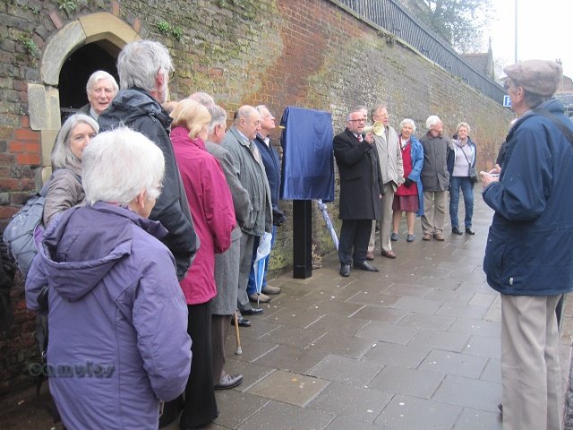
Councillor Henry Spyvee and a group of interested persons, formed the Friends of Colchester Wall in 2010, and they decided to raise funds to install heritage based information boards around the town's wall. The following is the one that was installed at the site of the East Gate, unveiled on 22nd November 2014. Councillor Tim Young with the hailer, with Mr and Mrs Spyvee to his left and local historian of renown, Mr Andrew Phillips, to their immediate left. The group was disbanded in 2020, when the project had been completed.
8e 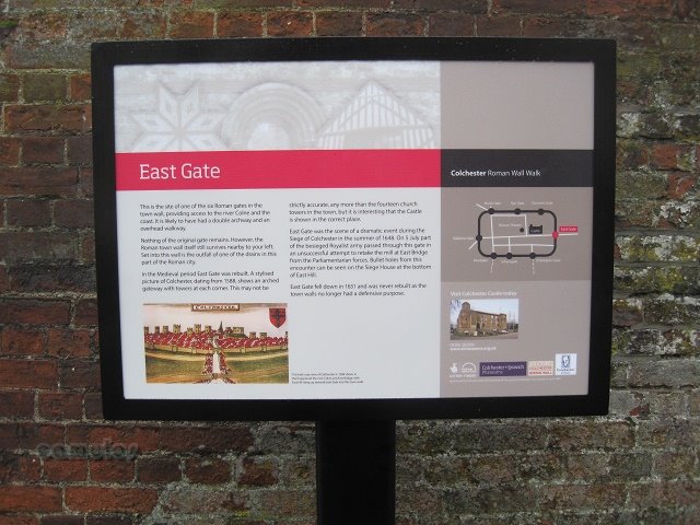
8f
8g
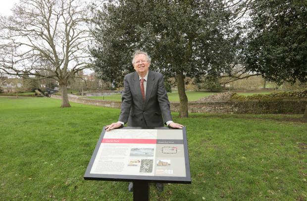
Mr Henry Spyvee, ex-Mayor of Colchester and ex-Colchester councillor, alongside one of the signs that he was instrumental in creating.
We will now walk along Priory Street for the next part of our tour.
9a
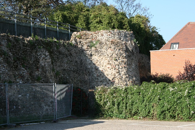
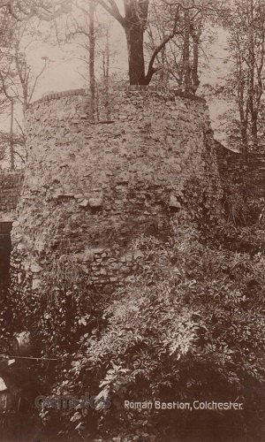
A MEDIEVAL BASTION (No 1)
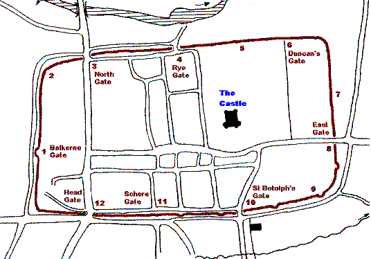
This is the first of the eight known medieval bastions that we will be seeing on our tour. We should point out at this stage that the Speed map of 1610 (a section of it below) shows the town as it was at that time. It appears to show the eight bastions on its southern and eastern sections of the town wall, each possibly sited at a point where there once stood a Roman period lookout tower. As so much of this section of the walls was badly damaged during the 1648 siege, we cannot now be sure of what existed.
9b
9c
RECENTLY REPAIRED SECTION OF WALL
As with so much of the wall. all we have here is the rubble interior of the wall, the exterior brick and sepataria courses having been lost in antiquity and the internal rubble infill stabilised. It works!
9d
BEFORE REPAIR ABOVE AND...
9e
AFTER REPAIR WORK ABOVE
WALL SECTIONS IN PRIORY STREET
Allowing vegetation to get a grip on the wall has a devastating effect on the masonry, which is forced apart by root growth. These walls needed work doing on them and this work was done in 2005 and 2013.
9f
BASTION 2 IN PRIORY STREET AFTER REPAIRS HAD BEEN CARRIED OUT IN SPRING 2005
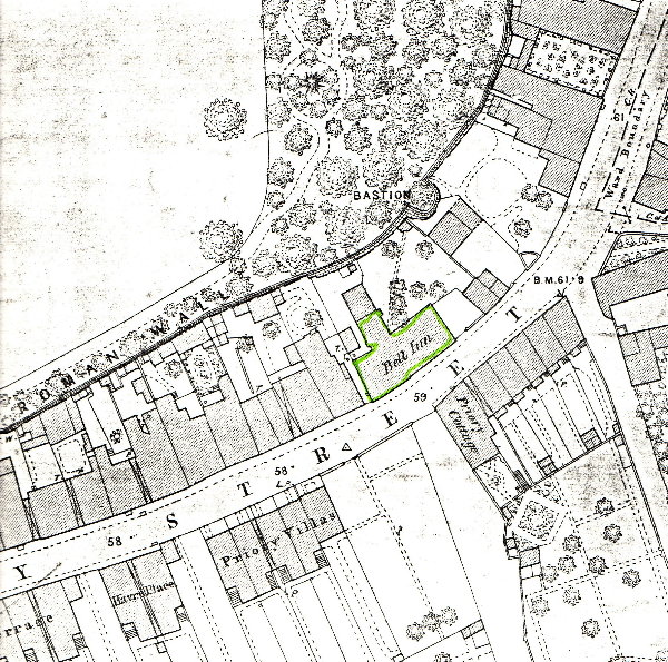
This bastion is shown on the following 1876 map, and shows the housing that backed onto the wall, before it was all swept away to create car parking space.
9g
1876 MAP EXTRACT SHOWING THE WALL'S ROUTE
This map is amazingly detailed and meticulously shows the wall as it existed in 1876, when many of the buildings that are shown have since been demolished. The Bell Inn was closed in 1913 after it was found to be operating as a brothel. The wonky wall line is of the later brick repair which you will see in the next pictures. It does not follow the Roman wall line along this section, presumably to 'grab' land for gardens. Civil War and 'Progress' has seen much damage caused to the wall, some of which I shall be showing you as we move around the wall route.
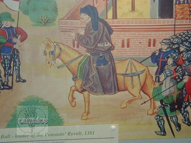
These bastions were added to the Roman wall during the reign of King Richard II (1377-1399). He had become king at the age of only 10 years and was guided by John of Gaunt and his chancellor, so, at the time of the Peasant's Revolt in 1381, he was only 14 when he found himself having to deal with the likes of the revolt leaders Wat Tyler and John Ball. Both had links with Colchester but the latter was a Colchester preacher, a monk, later to die horribly as was the custom of the time through being hung, drawn and quartered, for his treason against the king. Perhaps this connection led to the building of the bastions as a visible warning to the people of Colchester of the might of the king. There are those in the town today who would like to erect a statue to John Ball, as a hero of Colchester. Hero or traitor?
9h
Something that is not well known about Colchester is the effect of plague on our population. The Black Death claimed the lives of over 1000 Colchester people in 1348 (out of a total population of 4000 to 5000 people) and had a similar effect right across England. So much so that the peasants were in short supply to carry out the necessary work in the fields for their masters. As a result they naturally demanded higher pay, failing which, they took their labour elsewhere. The culmination of all this was that the various kings of that period brought about measures to drive costs back down again to levels before the plague, resulting in the peasants revolting. The youthful Richard II brought it to a bloody end.
9i
18th CENTURY WALL SECTION IN BRICK
Just beyond the second bastion there is a particularly ugly section of wall, the result of early 18th century repairs to replace a section of the Roman wall that was destroyed during the Siege of Colchester by parliamentarian forces in 1648. Whilst this probably classed as some of the earliest brickwork in Colchester, others might say it is grotesque. Why it fails to follow the exact line of the Roman wall that it replaces is unknown! A bit of 18th century land grabbing perhaps?
As you can see, the 300 year old brickwork is suffering from decay. This opening through the wall's perimeter is just one of many that have been added over the centuries, the threat of invasion and the usefulness of the wall as an effective means of defence, now a thing of the past.
9j
AN EDWARDIAN POSTCARD VIEW OF ONE OF THE BASTIONS - WHICH ONE THOUGH?
Bastions served to give defenders a greater view of any attacker who might use the cover of the wall to remain hidden. Three of these remain in Priory Street alone, with another surviving on the south wall.
9k
THE ROMAN WALL FURTHER ALONG IN PRIORY STREET
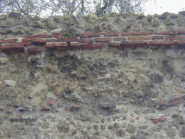
Note the Roman tiled course at high level. This section of the wall has been heavily repaired over the years, hiding much of the original Roman work.
9l
A CLOSER VIEW OF THE TILE COURSE
These tiles will soon fall away unless repairs are carried out. Colchester Borough Council have a continuous plan for repairs to be done as part of their responsibility to maintain this Scheduled Ancient Monument and grant funded by the government.
9m
A BREACH IN THE WALL IN PRIORY STREET (LOCATION OF BASTION FOUR, SINCE DEMOLISHED)
This would have provided vehicle access at some point in history, sealed up more recently. We know that a bastion was located here as its foundations were excavated in the 1980s whilst the car park was being created. This location directly lines-up with Duncan's Gate on the north wall, so is an indication that there may have been a postern gate at this position in Roman times too. This area is now covered by a car park.
In the 19th century, the road was lined with housing along both sides. More recently, the houses were demolished on this side to enable the car park to be provided. There's a Quaker graveyard under the tarmac too. There are plans to remove the car park and turn the whole area into public gardens, where the Roman wall will be made into a tourist feature. Such is progress - if it ever happens!
9n
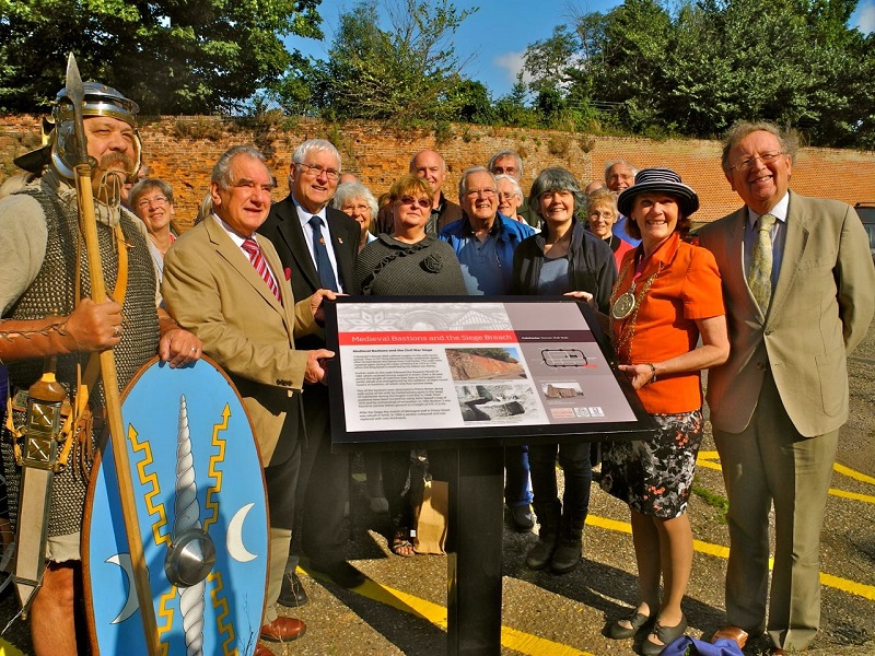
The above picture is of another of the information boards enabled by the Friends of Colchester Wall, flanked by Longinus, a Roman soldier, Mr Mark Davies, Sir Bob Russell (High Steward of Colchester and ex-MP for Colchester), Councillor Lyn Barton, Councillor Mrs Theresa Higgins (Mayor of Colchester) and Mr Henry Spyvee (Friends of Colchester Wall, ex Colchester councillor and ex-Mayor of Colchester). Also Mr Patrick Denney (local historian and author), Mr Bill Frame, Mr Andrew Philips (local historian and author), Mr Dick Barton, etc.
More names please.
9o
THE FIFTH BASTION IN PRIORY STREET
This is probably the best preserved of our medieval bastions.
9p
BASTION FIVE'S WINDOW FEATURE A delightful window feature in the top - but what defensive capabilities did it afford? Note the 'put' holes that give the clue to the medieval origin of the bastions. These holes were where logs were 'put' to support scaffolding for building and repairs - and for pigeons to nest in. 9q
BASTION LOOKING NORTH
Surely the best preserved of all the medieval bastions and surely worthy of a better display. Note the 'put' holes for the medieval scaffolding. Holes to 'put' the support beams.
Sadly, there is controversy here. In the 1970s, a new bus station was built on the land directly behind this bastion, which became a bit of an eyesore after some years and which was closed down in the 2010s, leading to more controversy from bus users, who didn't like the new location in Osborne Street - but that's another matter. With, what appears to be, uncharacteristic haste and by ignoring the covenant that exists on this land, Colchester Borough Council defty side stepped the plan for the heritage quarter ideas, that had been the plan for the site, and took up with a property developer who wanted to cram the site with student accommodation and a hotel, despite there being no college or university in the town requiring such accommodation and no need for further hotel rooms in the town centre. There was to be no car spaces for the new occupants, nor any facilities for public enjoyment. The town's Roman wall was in danger. Our archaeology was in danger. Our ability to prevent this plan coming to fruition was in danger. So how would it all pan out?
We write this in May 2021, so we will let you know.
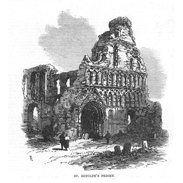
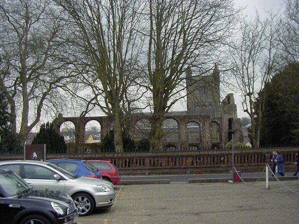
We have come to the end of the Priory Street car park and if we turn and look in a southerly direction we can see our 12th century St. Botolph's Priory, the first Augustinian priory built in Britain and well worth a detour from our town wall walk.
Controversy! THE HERITAGE QUARTER
(as optimistically named in the 2010s, in anticipation of a great opportunity for this site).
This is an aerial view of this part of the wall that has been modified by adding the proposed new buildings, crammed onto the space once occupied by our previous bus station. The new buildings are circled and the bastion that we have just shown you is arrowed. The big building to the right of of the picture is Colchester's Firstsite art gallery facility - another controversial addition to Colchester's heritage core. All of the land within the walls is where the Romans built their colonia buildings, with Roman remains yet to be properly archaeologically excavated. 9r 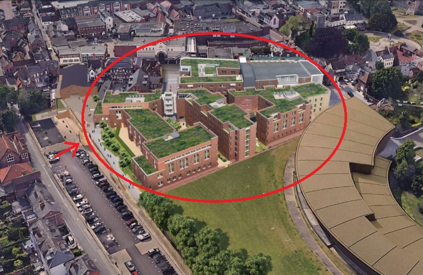
9s
Where best to go for comment about this? How about to Mr Will Quince, MP for Colchester, elected by the people of Colchester to act for them?
This is a selection of his comments that he made in opposition to the plan.
9t
9u
10a
ST. BOTOLPH's PRIORY IN THE MIDDLE GROUND AND THE CHURCH IN THE BACKGROUND
Before proceeding to the site of the South Gate (or St Botolph's Gate), we cross Priory Street to take a look at some of what is left of St Botolph's Priory. Founded in 1105 by the Augustinian order, it must once have been a magnificent structure.
The dissolution of the monasteries under King Henry VIII in the 16th century, led to our St Botolph's Priory falling into decline - but it was the cannon ball that reduced it to the sorry state that it is in now. St Botolph's Priory was the first Augustinian priory built in this country, having authority over all other houses of the order in this country. It would have had thirteen inmates, comprising one prior and twelve canons, indicative of Christ and his disciples. It was never a wealthy endowment, despite its seniority amongst Augustinian houses.
10b
Note the heavy use of Roman bricks, which would have been readily available to the builders from the collapsed Roman buildings of 600 or so years earlier. The town was abandoned and unhabited soon after AD 411, when the Romans left these shores for good. The materials that they had produced enabled the Normans, after 1066, to very efficiently remove most traces of Roman Colchester (leaving the walls of course due to their military defensive importance). By plundering the Roman building materials for their Norman buildings, we still have remains such as Holy Trinity church, St Martin's church, Colchester Castle and, of course, St Botolph's Priory, where the use of such materials is evident.
10c
10d
If we look at this amazing building, extensively constructed from Roman materials from robbed out Roman buildings, we turn to the right and arrive in St. Botolph's Street, where once stood one of the main Roman gateways into the colonia. We will call it St. Botolph's Gate, although it may also be known as South Gate, for obvious reasons. There is now no evidence of any Roman wall or gate structure and so no picture is shown. All we do know is from the Reverend Philip Morant's commentary that I have previously referred-to and on old maps. Nothing is known of its size or shape - and there we must leave it.
10e
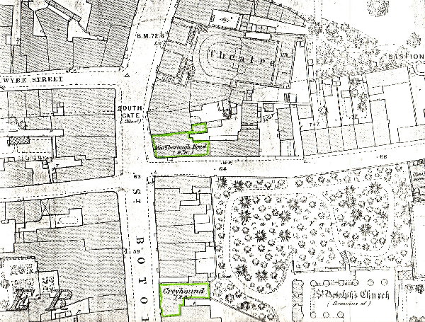
1876 MAP INDICATING ST. BOTOLPH's GATE (OR SOUTH GATE)
This map shows the fifth bastion on the far right and the position of the Roman wall and gate. The two pubs shown and the theatre are now all gone, an indication of 'progress'. The church shown refers to the priory. Short Wyre Street would have followed the line of the ramparts of the wall, with a steep incline down to Vineyard Street, outside the wall.
But, before we move on, let us take a look at Markhams, the pawnbrokers.
10f
MARKHAM'S IN PRIORY STREET
They have been on this spot since 1840 and have rendered an invaluable service to their clients over these many years. The building is shown on the map above, directly to the east of the Marlborough Head public house. At a pawnbrokers, one can take an item of value (a pledge) to the pawnbroker and get a sum of money for it, on the understanding that, when you wanted the item back again, you gave the pawnbroker back his money, plus a fee for his services. It all sounds very straightforward, but using the services of 'uncle' became an essential part of life for the poorest classes. An old gentleman (Mr Harry Parratt, now deceased) told us of his time working for Mr Markham in the 1920s. It was his first job, at the age of 14, and a real 'eye-opener'. He clearly remembered two particular ladies who, every Monday morning, would arrive at the side door to 'pledge' their husband's suits. They would get a pound for each suit. The suit would be wrapped up and put on a shelf upstairs with all the others. Sure enough, the next Friday, after their husbands had got their wages, they would be back again to redeem their pledges, so that the husbands could go out drinking in their best clothes - and then, at pub closing time, home to beat their wives. Of course these are extreme cases, but this is what went on here. Markhams are a thriving business to this day, so the services of the pawnbroker are still very much needed by townsfolk.
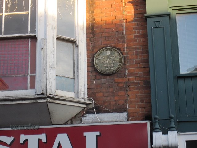
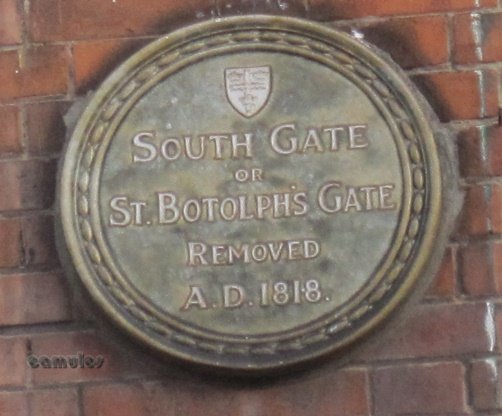
As we get to St Botolph's Street , we turn right and walk up the hill a little. Looking up high on one of the shop buildings, we see this plaque, telling us that this was where the gate was and that it was removed in 1818, probably due to its dilapidated state. The clue here is the steep rise in the roadway, where 'outside the walls' was a good deal lower than 'inside the walls', an important defensive feature in the days of the colonia.
10g
10h
SOUTH GATE
We now have a choice between walking across the site of the gate and 'inside the wall', along Short Wyre Street and Eld Lane until we reach Vineyard Steps, or staying 'outside the walls' by crossing over St. Botolph's Street and proceeding along Vineyard Street. We will take the latter route along Vineyard Street where there is no visible sign of the wall, until we reach the Vineyard Street car park. The buildings that run along the left hand side of Short Wyre Street and Eld Lane, are all built atop the Roman wall. Those along the right of Vineyard Street are built at a lower level, against the Roman wall.
At a point directly opposite Long Wyre Street on the higher level at the junction of Short Wyre Street and Eld Lane is our final (the sixth - we think) medieval bastion that can still be seen. The following map extract shows it and the photograph shows what it looks like today.
10i 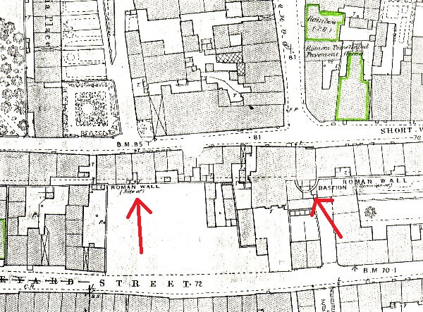
1876 MAP DETAIL OF SIXTH BASTION
10j
A short way along Vineyard Street, through a gap on the right, next to Robert's Bar, you will be able to see the sixth bastion hidden away, with a shop in Eld Lane perched on top of it. Another day, why not ask in the shop about how they use the bastion? It will be easy to locate as it faces directly onto Long Wyre Street.
We now continue along our route into the car park, a general area that was once renowned for its ladies of negotiable affections. A hundred or so years ago, this was Colchester's red light district, especially popular with the soldiers from the nearby barracks who, prevented from taking wives, without their officer's permission, sought female company in other ways. You can learn more of this here - but don't forget to come back again. Thirteen premises were examined and some closed down in one year (1869) for their nefarious and clandestine practices!
(These map extracts highlight public houses because that is another of my favourite historical subjects. You can find out more about our pubs here, but please don't forget to come back again for the remainder of our tour.)
10k
VINEYARD STREET CAR PARK
10l
10m
As you can see the wall blends in with a real hotch potch of materials and buildings whose frontages are in Eld Lane at the higher Roman rampart level. The wall has been considerably knocked about over the years.
10n
SMALL BOY (HARRY, 18 in 2013) STUDIES ROMAN DRAIN
A little further along there is a Roman drain feature which links up with the all important Roman period drain outlet within the colonia. The view below shows the drain and, to its right, evidence of a time when a house was built against the wall. At about a metre above the present day ground level is a wooden fire place mantle with the sooty brickwork of its chimney above. Note that the Roman drains were big enough for a person or child to crawl through for cleaning purposes yet not big enough to enable a big burly attacker with sword and shield to pose a threat to the colonia.
10o
Even further to the right is shown below a modern day breach through the wall where, it is believed (from the evidence of John Speed's map of 1610) once stood another (the 7th) of the medieval period bastions.
10p
To the left is the modern day Vineyard Steps that lead up to Lion Walk Shopping Centre.
10q
VINEYARD STEPS LOOKING WEST
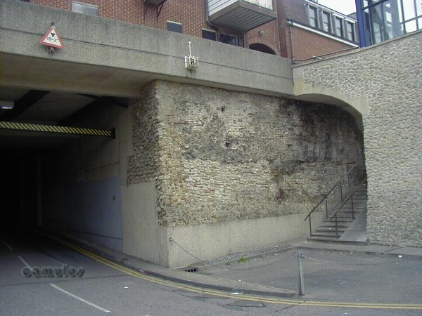
A section of the Roman wall which has been used to provide a modern day high level entrance into the town centre, to provide car park access for shoppers.
10r
LION WALK UNDERGROUND LOADING BAY ACCESS
A modern day breach in the wall provided to give vehicular goods access to the Lion Walk Shopping area. The final eighth bastion once stood here. This destruction of part of a scheduled ancient monument was very worrying to local people and archaeologists at the time (and still to this day, with covetous and ruthless property developers ever present and threatening). This town centre development was a rape of our town, unseen since the time of the attack by Boadicea. Pictures of the work being done at the time, with so many old buildings being destroyed in the name of progress, were a great shock to us at the time. Now, all we have is memories of how things once were.
Remember, this is a Scheduled Ancient Monument. Special permission was granted to mutilate it in this way. Money talks! May it never happen again.
10s
LION WALK GAP
A most unappealing piece of our historic Roman wall!
10t
ROMAN WALL IN VINEYARD STREET
After this piece of our wall, it disappears into the mix of buildings along St. John's Street until we arrive at Scheregate Steps.
As we approach the area of the town centre now known as Headgate, if you take a look in the building known as the Lemon Tree restaurant, you will see that part of the eating area is set into a breach in the wall, gaining an extra eight foot of space for the restaurateur. It is not known when this piece of archaeological vandalism was done but it certainly makes for an interesting setting for a dining experience. If anybody were to try this today, there would be serious consequences.
THE LEMON TREE RESTAURANT
We now walk on westwards until we arrive at a crossroads known as Headgate, with the ancient Fox and Fiddler (its fifth name - previous names being Ship, Elephant and Castle, Headgate, Boadicea, Fox and Fiddler) pub on the left, and the even more ancient Bull pub (the oldest recorded pub in the town), a little further on, in Crouch Street (the road named after the Crouched Friars' friary that was once near by).
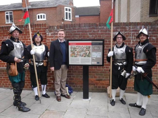
The picture above is of another of our information boards that was enabled by the Friends of Colchester Wall, this one at Headgate, the site of one of the principal Roman gateways into the colonia. Here we see Mr Will Quince, MP for Colchester, joined by members of the Colchester Town Watch, soon after the sign's installation.
12c
HEADGATE
All trace of the Roman gate is now gone above ground, although archaeologists uncovered its exact footprint during work in the 2010s. All that we can show you is the picture of the area above, looking east. To mark the gates position, a stone is set into the wall of a shop with a date of 1783 or 5, and GR for George Regis, presumably George V, not George III. A mystery! The date presumably records when the gate was removed.
As we stand at Head Gate, there is no sign of the wall. The tell-tale falling away in height of the road as it goes off south as Butt Road, tells us of the height difference between inside and outside the colonia walls. We last saw the wall at the restauarant in St John's Sttreet, and the higher level Sir Isaac's Walk that runs parallel to St John's Road is lined with shops that sit on top of the wall, all obscuring it from sight.
Now we turn westwards and walk along Crouch Street, with shops along each side, completely obscuring the wall which is to our right. One shop at least along here has a little door that opens on to the wall surface, as a small cupboard. Otherwise that is all we have to tell us that it is there. We eventually arrive at Balkerne Lane, on the last part of this, our virtual tour.
12e
THE SOUTH WEST CORNER ON BALKERNE HILL
This is the beginning of all that remains of the visible part of the wall in the south west corner on Balkerne Lane. St Mary at the Walls church can be seen in the background. Here is a particularly malformed section of the wall, looking a little as if it was produced from a lava flow and with various sections cut into it, presumably from a time when dwellings were built against it. What we are actually seeing here is a section of the wall that has fallen forwards and has stayed there. When this happened is not known, but was probably connected with undermining works associated with adjacent buildings - or simply from ancient subsidence. Where you see the rear end of the blue car would once have been 5 metres or so of rampart earthwork from the Roman period. At this point, all the earth has been removed in recent times to create a car park and for the construction of the hideous 1960s building behind it. If we walk a little further you will get a better idea of what has happened here.
12f
Here we look south and can clearly see how the wall has toppled. To the far end of the section you can see the original Roman foundations of the wall, now floating in mid air. Also how the wall has split in two due to this movement. Interestingly too, the excellent condition of the brick and sepataria courses suggest that this movement has only occurred in more recent times, as weathering has not talken its toll. Of course, the Roman builders built their wall to look good from both sides. It was presumably at a later date that they decided to build up an earth infill rampart, inside the wall, thus preserving the inside face of the wall - until uncovered many centuries later when this sort of collapse happened.
12g
ST. MARY AT THE WALLS
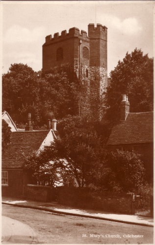
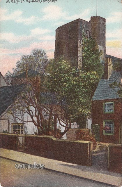
Crossing over Balkerne Hill we look back in a north easterly direction to view St. Mary at the Walls church. The church has been deconsecrated and is now known as the Colchester Arts Centre - for a few years now the home of the Colchester Beer Festival. This is the church that is associated with the one eyed gunner Thompson who allegedly caused such irritation to the parliamentary forces during the Siege of Colchester in 1648 with his accurate cannon fire. The church tower bears witness to the damage caused by the return fire which brought 'Humpty Dumpty tumbling down'. The blasted away top section of the 15th century tower was repaired in brick, instead of the re-used Roman materials that the rest of the tower is constructed from. Indeed, the whole south west corner of the town wall was heavily damaged by Parliamentarian Army cannon fire, and much of it is missing. Next to the church can be seen Jumbo, and next to that, the Mercury Theatre.
We will now cross back over the road and take a look at the West Postern.
12h
THE WEST POSTERN GATE ON BALKERNE HILL
This passageway was cut through the wall, presumably for ease of access to the medieval period church of St. Mary at the Walls. It is not a Roman gateway, although a Roman drain runs through this area. The evidence for this in the Roman tiling on the left which is part of the archway of the drain outlet and which was opened-up to form a postern at some point in history. The steps are from around the 18th century. Also on the left (at the rear or the wall) is further evidence of a Roman lookout tower which was one of many around the wall, which we mentioned earlier in our tour.
12i
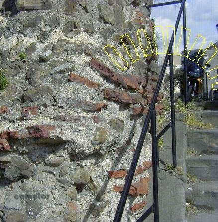
INTERPRETATION OF BARREL ARCH
The yellow lines show how the drain was once constructed and which made it easier for a breach to be made for pedestrian access. Please take a look at picture 10n to give a better idea of how the drain outlet may once have looked.
...AND SO, WE CONCLUDE OUR TOUR
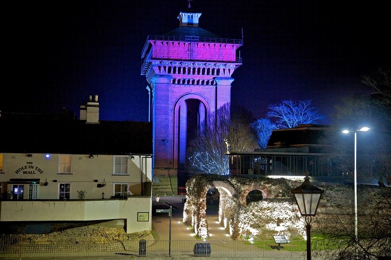
All lit up, thanks to an initiative of Councillor Darius Laws, who brought about the illumination of sections of our wonderful town wall.
1
2
3
In terms of size, Colchester's Roman Wall was 2,800 metres (3062 yards or approx. 1.75 miles) long and 2.4 metres (8 Roman feet) thick. Due to weathering damage and almost two thousand years of little boys climbing the walls, we cannot be sure of the original height. It is estimated that it must have been at least 6 metres (20 feet) high, including the battlements. The wall incorporated six Roman gates (Balkerne, North, Duncan's, East, St. Botolph's, Head, East) and several other later incisions; which include Rye Gate, Castle Park (two), Castle Road, various un-named in Priory Street, Lion Walk Gap, Shere Gate, Culver Gap, West Postern and various other smaller access ways. There would have been between 12 and 24 Roman observation towers, the clearest one in evidence on Balkerne Hill.
It has been estimated that the walls must have required over 45,000 cubic metres of stone, tile, and mortar. That's something like 80,000 tonnes in weight, including perhaps 40,000 tonnes of septaria that had to be brought from near and far away.
Without a doubt, this was the biggest statement of power that our Roman conquerors ever produced in Colchester. They were here to stay - or so they must have thought!
How did they do it?
We are now off for a virtual pint at one of our few pubs that are still in business.
How about you?
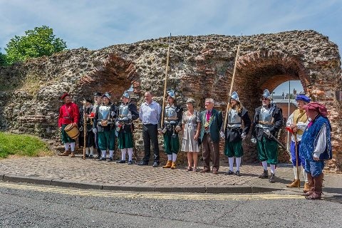
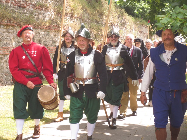
THE COLCHESTER TOWN WATCH
Every year, the Mayor of Colchester is invited to take a perambulation of the town walls, accompanied by the Town Watch, the mayor's civic bodyguard. This is done on the vigil of St. John the Baptist (23rd June, or thereabouts). This is a custom from the time of King Henry III, who commanded that watches be kept in cities and towns to preserve the peace of the realm. The procession sets off from the castle, marching to the beat of the drum, following the perimeter of the Roman walls and including a short stop for 'cakes and ale' at the Hole in the Wall. If you would like to join them, please seek out news of Town Watch at a nearby hostelry.
If you have found this tour interesting, please tell your friends about it and ask them to remind our hard working borough councillors of the importance of care for our walls. That way, we can help ensure that the oldest town walls in Britain are maintained, conserved and presented to the maximum benefit of us all and for future generations to come.
Sadly, despite all the talk of 'What the Romans did for us', what the Romans didn't do for us was leave a long term maintenance contract for the maintenance of 'their' wall!
Your tour guide has been
Longinus Sdapeze
sdapeze@aol.com
return to the
Home Page
last updated
250521

 5c
5c


 12l
12l 12m
12m